 Route Editor

| Guide | ♦ | 80 Triplogs | 1 Topic |
details | drive | no permit | forecast | 🔥 route |
stats |
photos | triplogs | topic | location |
| 1.4k | 80 | 1 |
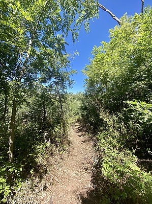
Let's play another round of Black Bess by joebartels  History HistoryBaker Mountain was homesteaded by real country hicks: Peterson's Life Story. Edward Abbey (1927-1989), an environmental writer, worked for two seasons as a lookout at Aztec Peak and referred to it in one of his books. Overview Abbey's Way Trail #151 ascends the southwest slope of Baker Mountain to Aztec Peak. It was a beautiful mixed conifer forest surrounding the trail until the 2000 Coon Creek Fire and 2016 Juniper Fire advanced the cycle of life. While large stands of pines have been wiped out, it is not a moonscape. Sierra Ancha means wide mountain range.
Abbey's Way leaves Workman Creek Road (FR 487) at the Peterson Trailhead, there is little signage. It is wise to have the Official Route loaded on your device as the first few strides have historically been overgrown but easy to decipher if prepared. The trail heads northeast around a mountain meadow. The meadow was part of the Peterson Ranch homestead ~1914 to 1939. The trail then climbs directly up the former Ponderosa Pine and Douglas-fir covered slopes of Aztec Peak towards the lookout tower. The trail wraps around the peak and meets FR 487 at the top of the peak. Flinstone furniture minutes to the southwest is a great spot for a break or lunch with outstanding views. Loop Aztec Peak via Abbey's Way 151 Loop is a great option. Enjoy abundant distant views along the road in the upper half without constantly keeping your eyes on your footing. Extended Off-trail Options Albeit enjoyed as-is by most, off-trail options include Baker Mountain in full or a shorter off-trail hike over Murphy 7732 to Reynolds Creek Trail #150 for fabulous extended trail network hiking over Center Mountain. FR487 Gate Typically closed December 1st thru April 1st. Check with Tonto FS. In recent years, the road has been in need of repair and closed to vehicular access. Hiking the road or hiking Parker Creek Trail #160 are two common alternatives to access. Synopsis As of September 2022, this trail has been cleared of deadfall and brush, get out and enjoy it. It is rich in history with plenty of options to extend the little trail. Temperatures are consistently 15-20 degrees cooler than in the Phoenix metro area. My first backpacking trip was along #151. 50-second Video Check out the Official Route and Triplogs. Leave No Trace and +Add a Triplog after your hike to support this local community. One-Way Notice This hike is listed as One-Way. When hiking several trails on a single "hike", log it with a generic name that describes the hike. Then link the trails traveled, check out the example. | ||||||||||||||||||||||||||||||||||||||||||||||||||||||||||||||||||||||||||||||||||||||||||||||||||||||||||||||||||||||||||||||||||||||||||||||||||||||||||||||||||||||||||||||||||||||||||||||||


