Route Editor

| Guide | ♦ | 16 Triplogs | 0 Topics |
details | drive | permit | forecast | route |
stats |
photos | triplogs | topics | location |
| 64 | 16 | 0 |
It All Starts Right Here! by chumley  History HistoryArizona's Initial Point (the intersection of the baseline and primary meridian now known as the Gila and Salt River Base Line and Meridian respectively) was officially established in 1865 by John A. Clark, the Surveyor General for NM and AZ. This followed the Gadsen Purchase, completed in 1854. For the previous six years (under the Treaty of Guadalupe Hidalgo), the Gila River was the international boundary between the United States and Mexico, making this small hill at the northern terminus of the Sierra Estrella Mexican territory. The point had originally been marked with a monument by a Mexican Boundary Commission crew led by Francisco Jimenez in the early 1850s. In 1867, the first survey was conducted from the initial point, covering 36 miles in 5 days. Benchmarks If you ever encounter survey markers around Arizona you can figure out how far you are from Monument Hill. Each Range and Township is 6-miles. So the 6x multiple of the township and range numbers stamped on the benchmark will tell you your distance from the Salt and Gila Base Line and Meridian. (There are some deviations to this system because the land is not flat, but that's the basic premise). All survey marks in Arizona are established from the Initial Point on Monument Hill!
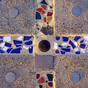
The monument originally constructed at the Initial Point was a stone and concrete structure six feet high and eight feet in circumference at its base, with a four-foot circumference at the top. From the top of the stone monument, an 8-foot pole jutted higher into the sky, making the total height of the monument fourteen feet. I can't find any photos or information on when the original was destroyed, but it was long gone in 1984 when six agencies got together to refurbish the monument. (BLM Cadastral Survey Team, AZ State Lands Dept, Salt River Project, Gila River Indian Community, AZ Professional Land Surveyors Assn, and Bureau of Reclamation). The 1984 refurbishment was not a replication of the original tall monument, but rather the flat concrete cross that exists today. In 2002, the monument was awarded status on the National Register of Historic Places. A plaque indicating its historic status was erected near the monument and can be seen today. Additional refurbishment occurred in 2006. Location and Access Monument Hill is divided by the principal meridian, with the west side belonging to Phoenix International Raceway (PIR) in the City of Avondale, and the east side belonging to the Gila River Indian Community. While there are currently no signs posted prohibiting access--and a well-traveled trail (the remnants of an old road) leads to the summit on Gila River Indian Community land--hiking and other kinds of recreation on Gila River land is subject to tribal laws and regulations. Please make sure you are in compliance before proceeding onto tribal lands. The west side of the mountain is owned by PIR. Monument Hill is used for seating during race events. Access to this side of the hill is only permitted during race events with a valid ticket. During non-event days, access to the hill requires the permission of PIR, the owner of this private property! Please respect private property and obtain the necessary permission to hike on any non-public lands! Keep in mind that if there is an event at PIR, more than 75,000 fans may be in attendance, making traffic and parking an issue. You will very likely be unable to park anywhere near here without a ticket. Hike From the parking area, proceed through the gate into the B&M Wildlife Area. A gate in the fence along the walkway opens to the east. Proceed down along the base of Monument Hill following the old roadbed. Follow it as it turns southward and climbs the mountain. The monument and register are clearly marked at the peak. Head back the way you came, or follow the road south along the fence line toward the racetrack before turning back toward the parking lot. Also Nearby The Base & Meridian (B&M) Wildlife Area is a 200-acre BLM preserve at the confluence of the Salt and Gila Rivers managed by Arizona Game and Fish. This is a wetland riparian riverbank habitat and is open to recreation including fishing. There are excellent bird-watching opportunities with common species including: white-winged dove, mourning dove, Gambel's quail, coots, Yuma clapper rails, western yellow-billed cuckoo, and gallinules. Other wildlife includes common yellowthroat, great blue heron, belted kingfisher, western screech-owl, beaver, bobcat, desert kangaroo rat, javelina, California kingsnake, Sonoran mud turtle, and western diamondback rattlesnake. Additionally, special status species including Lowland leopard frog, Ferruginous hawk, great egret, loggerhead shrike, osprey, American peregrine falcon, southwestern willow flycatcher, California leaf-nosed bat, and Sonoran desert tortoise occur on or near the B&M Wildlife Area. (Species reported via azgfd.gov). Gate Policy: If a gate is closed upon arrival, leave it closed after you go through. If it is open, leave it open. Leaving a closed gate open may put cattle in danger. Closing an open gate may cut them off from water. Please be respectful, leave gates as found. The exception is signage on the gate directing you otherwise. Check out the Official Route and Triplogs. Leave No Trace and +Add a Triplog after your hike to support this local community. | ||||||||||||||||||||||||||||||||||||||||||||||||||||||||||||||||||||||||||||||||||||||||