 Route Editor

| Guide | ♦ | 26 Triplogs | 0 Topics |
details | drive | no permit | forecast | 🔥 route |
stats |
photos | triplogs | topics | location |
| 199 | 26 | 0 |
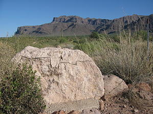
A View To A Mine by AZLOT69  2026-03-06 Cloudview to Jacobs is closed due to a private property dispute. STAY OUT! 2026-03-06 Cloudview to Jacobs is closed due to a private property dispute. STAY OUT!This section of the Lost Goldmine Trail is the Black Sheep of trails in this area. It has received little use since the efforts to build it several years ago. The accomplished goal was to connect the Peralta trail system and Hieroglyphic Trail #101 to the Lost Dutchman State Park trail system. This was tricky as it involved private land, State Land, and the Tonto National Forest. Lack of signage and a formal trailhead has hurt its success. Change is in the air as the Tonto National Forest has formally recognized, numbered, and signed the trail on the federal land.
If you lose the trail, just head north. Some homes will be on the right, and as long as you stay west of them, you are good. Cairns are scarce but huge. Several years ago, a scout project was to make this trail more horse-friendly, and they removed many stones from the trail, making huge cairns along the way. At one-third of a mile, the houses end, and the trail is better defined as you approach a gate that enters State land. The trail continues north and stays within sight of the boundary fence, which is on the right for the distance north. The trail crosses an old burn area that has not totally recovered. The view ahead is a profile of the Ridgeline Hike from 5057 to the Flatiron. At about one mile, large old-growth appears, and new overgrowth is eating away at the trail. It meanders but keeps the north direction and stays in sight of the fence. At 1.43 miles, the trail takes an abrupt left, and so does the fence. Keep the fence on your right as the trail heads west. At 1.57 miles, you arrive at an old jeep road and a large deep wash. This is the Hog Canyon trailhead. Take the jeep road left toward the south for 50 feet. Watch for two large cairns on the right as the trail dives into the wash at this point, crosses, and out the west side of the wash. The growth in this area is mature and impressive. The center part of the hike was my favorite. The trail is easier to follow from here on out. It is very rocky, and although mountain bikes are allowed, I would not recommend them. At 2.76 miles, another gate appears and you enter the Tonto National Forest. Halfway up the mountain in front of you is a cave. This is the Broadway Cave, which has a mine in it. You can now see the Valley of the Sun and pick out some prominent features on the horizon. The Lost Goldmine Trail ends at Jacobs Crosscut # 58. Take a left for one-half mile to the Broadway trailhead or make a right for continued adventures such as Monument Canyon, Broadway Cave, or the Lost Dutchman State Park. Gate Policy: If a gate is closed upon arrival, leave it closed after you go through. If it is open, leave it open. Leaving a closed gate open may put cattle in danger. Closing an open gate may cut them off from water. Please be respectful, leave gates as found. The exception is signage on the gate directing you otherwise. Check out the Official Route and Triplogs. Leave No Trace and +Add a Triplog after your hike to support this local community. One-Way Notice This hike is listed as One-Way. When hiking several trails on a single "hike", log it with a generic name that describes the hike. Then link the trails traveled, check out the example. | ||||||||||||||||||||||||||||||||||||||||||||||||||||||||||||||||||||||||||||||||||||||||||||||||||||||||||||||||||||||||||||||||||||||||||||||||||||||||||||||||||||||||||||||||||||||||||||||||||||||||


