Route Editor

| Guide | ♦ | 14 Triplogs | 5 Topics |
details | drive | no permit | forecast | 🔥 route |
stats |
photos | triplogs | topics | location |
| 367 | 14 | 5 |
  History HistoryAt the beginning of General George Crook's campaign against the Apache Indians, Captain Burns and Major Brown combined their companies of the 5th Calvary and led them to a secret hideout on the north wall of Salt River Canyon above what is now Canyon Lake. Their guide was an apache scout named Nantaje. The soldiers approached the cave before dawn on the morning of December 28th, 1872. When they arrived, they fired upon the helpless Indians who happened to be Yavapai. The massacre lasted most of the morning and about 75 men, women, and children were slain. There were only a few survivors, who were taken with the soldiers. No one remained to bury the dead. The cave remained as it was until its rediscovery in the 1890s. Jeff Adam's found the cave in 1906 and reported it to valley newspapers. Walter Lubken was guided to the cave in 1908 where he photographed the bones and artifacts within the cave. It is believed that Brownie Holmes was one of his guides and is in some of Lubken's photos. Around 1920, the bones were removed and buried by some Yavapai Indians from Fort McDowell. Nothing remains in the cave now.
Hike from the nearest non-4WD location, Cottonwood Camp, to Skeleton Cave. If you approach via 4WD or boat adjust your triplog data as follows.
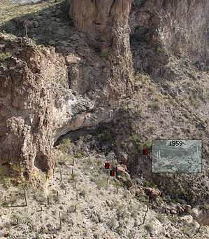
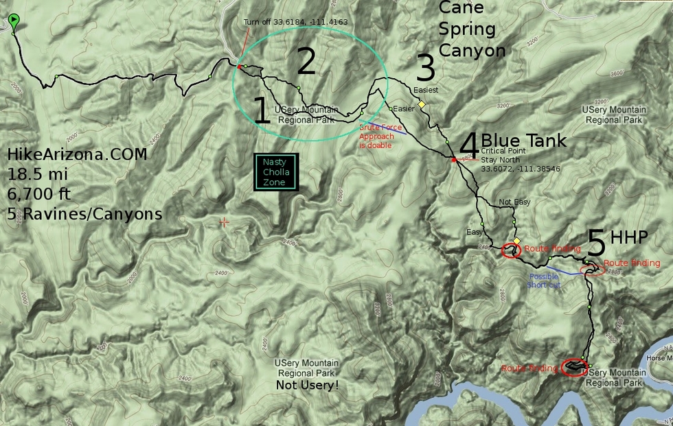
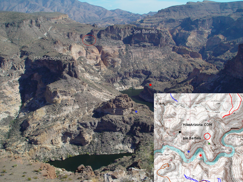
Warning This is an extreme dayhike crossing five ravines. You will undoubtedly refer to them as canyons on the return. Due to location, this hike is only feasible during the short days of winter. A moderate strong hiker will likely be 1 to 4 hours in the dark depending on the month. The terrain is seldom traveled, thick in cacti and far from help. Beware the four lethal Chollas, listed in order of pain: Chain Fruit Cholla, Christmas Cholla, Teddybear Cholla, Buckhorn Cholla. When the Cholla thins Prickly Pair blankets the terrain. Gear (Recommended based on optimal 60-70 degree daytime high) Pants, long sleeves, shirt layers (non-cotton for the bottom layer), headlamp, leather gloves, hat, one hiking stick/pole, tweezers. Thick leather shoes or boots save your feet from the dreaded "jumping" Chain Fruit Cholla. In addition to water & food, pain killers & B vitamins were a godsend in my journeys. Hike Follow FR401 2.7mi to the hairpin turn at 33.61844, -111.41631 depicted on the map. Head directly off trail due east into unnamed canyon #1. It is a steep hike down and may require the use of your hands or sliding depending on your route. Unnamed canyon #2 is wider. It's almost two ravines in one depending on how you tackle it. Further south keeps it to one ravine and the lowest point going over to #3. The energy saved is lost in time so it's a toss-up. Cane Spring Canyon has a wide base. You have nice views up to the Four Peaks and down to Sheep Mountain. It appears to flood based on the width of the channel. Your goal now is to get to a point in Blue Tank Canyon above where it etches an impassable crevice. View the map for your three choices of travel. The brute force route is non-technical albeit exhausting ascending over rocks. The easiest route follows the channel of Cane Spring NE, then a tributary SE. The confluence is brushy, the rest is nice non-brushy travel. This is the only decent place to break until Hell's Hip Pocket. The views improve again once in Blue Tank. Be sure to stay north of the critical point depicted on the map. You can't go south unless you enjoy scaling sheer rock walls. It's best not to travel in Blue Tank and head directly up the other side. Game trails contour down Blue Tank but they're covered in Cholla. So just get right out and head directly SE to the cave. Hell's Hip Pocket is the beauty of the hike. It can also be slightly technical depending on your route. We opted to follow the channel east until directly north of the cave. Check the map for a possible shortcut that looks doable on topo and satellite. If you follow the channel east you will eventually come to a double choke-stone ending. Go under the right. Note - I had difficulty getting back down on the return and needed assistance. Be careful on the other side as you must go up without slipping down. Now you are in what I call the tiers. We had to figure out two on the way up but only one on the way down. Staying east seems to be the ticket. Over the tiers, you are almost home-free! It's about a 600-foot climb on a nice open slope up to Peak 3235. It's a huffer but with scarce Cholla and the destination so close you don't care. There's no need to top out on 3235. Staying just east is your best bet. On the flip side, Salt River views come into play. Your route is very defined here as you are headed south into the obvious ravine. This ravine comes to an abrupt free fall directly over the cave. If you had the audacity to come here during a rainstorm the waterfall over the cave must be breathtaking! About a hundred yards before you feel you can't go any further you need to be traveling on the west side of the ravine. Upon reaching the edge you must go 0.15mi west along very steep terrain. Soon you'll catch views of the cave. Keep going west and head down 200 feet when you can, then go back 0.2mi to the cave. Return by the same route. As you are heading down to the cave contemplating your safety remember the native scouts did this barefoot in the dark! Skeleton Cave Once at the cave please remember to treat the area with respect. This was the scene of disturbing history. Overlook Ferg/Tessman's diagram of the cave. I would like to note this cave was published in Arizona Highways in Feb 1959 with full access details. Even though it's rarely been visited in the last twenty years it contained a mason jar in the 1960s that kept a registry of visitors. A bibliography is included so you can research yourself. Here are some of the more memorable pieces.
Note If you access via Hell's Hip Ridge stay away from the Horse Mesa Dam. Local dutch hunter Jim Hatt tells a tale that Homeland security has the area monitored with motion sensors. Stating when you trip a sensor that an Apache Helicopter will immediately be on route to pat you down. Dogs Allowed but not recommended due to the cacti. Sources
Check out the Official Route and Triplogs. Note This is a difficult hike. It would be insane to attempt this entire hike without prior experience hiking. Leave No Trace and +Add a Triplog after your hike to support this local community. | |||||||||||||||||||||||||||||||||||||||||||||||||||||||||||||||||||||||||||||||||||||||||||||||||||||||||||||||||||||||||||||||||||||||||||||||||||||||||||||||||||||||||||||||||||||||||||||||||||||||||||||||||||||||||||||||||