Route Editor

| Guide | ♦ | 95 Triplogs | 4 Topics |
details | drive | no permit | forecast | 🔥 route |
stats |
photos | triplogs | topics | location |
| 437 | 95 | 4 |
Canyons are inherently risky. Flash floods occur without notice on sunny days. Technical skills & surrounding topography knowledge required yet does not eliminate risk.
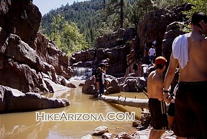
Gorge-us! by joebartels  Note NoteAccess has changed since this 2001 description. The highway is now divided and closer to the canyon. A hiker's adventure will range between 1 to 2.5 miles depending on where you park and desire to explore in the creek. Check the overview map in directions. Overview Christopher Creek Gorge is a popular summer weekend playground. I took the included photos the day after it rained. Therefore the water is muddy and doesn't appear to be so inviting. You can enjoy clearer pools if it hasn't rained in a week.
Hike Just into the hike, the trail appears to fork. You want to take the right-side trail that heads more south and away from the road. Soon you pass under electrical wires. Ponderosa pines surround you, and the trail zigzags through the forest. The trail, at times, is hard to find. This area has been trampled by heavy use and large groups. You will enjoy the thick classic forest along this section, though it might be a bit spooky at night. Manzanita, which I find to be unique, is dense in places. A rocky section of trail is encounter. The going is relatively easy, and the grade is a gentle descent. Several campfire rings are passed along the way. A clearing is reached, and trails appear to scatter in every direction. Keep heading South-Southwest. Across the clearing, the trail picks up again in the trees. Last I had visited the area; there was a sign marking this as the end of trail #298 with the same warning note. The sign was leaning against a tree, so it's very likely it could move. You will start to go up a slight slope, and the trail is rocky and narrow. The edge of the canyon is reached quickly from the clearing area. Bring an open mind; I heard yelling and screaming approaching the canyon. Once you have reached the canyon, it's best to keep following the trail hugging the edge down to the creek. Adventurous individuals head right down. Perhaps an occasional few rappel the sheer walls. Upon reaching the creek, you will need to cross the water. Follow the other side a short distance (west with the water flow) for the easiest access into the canyon. From here, it's up to you. Most make it past about two cascades with good size pools. Be careful on the rocks as the creek bottom is slippery. Enjoy your adventure and be safe! Check out the Official Route and Triplogs. Leave No Trace and +Add a Triplog after your canyon trip to support this local community. | |||||||||||||||||||||||||||||||||||||||||||||||||||||||||||||||||||||||||||||||||||||||||||||||||||||||||