Route Editor

| Guide | ♦ | 202 Triplogs | 23 Topics |
details | drive | permit | forecast | 🔥 route |
stats |
photos | triplogs | topics | location |
| 1.8k | 202 | 23 |
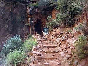
Death March by lobo41   Terminology TerminologySK - South Kaibab NK - North Kaibab BA - Bright Angel OBA - Old Bright Angel Routes SK ► NK 19.85mi / 6,200 AEG NK ► BA 22.15mi / 4,800 AEG (BA ► NK 6,300 AEG) SK ► NK ► BA 44.50mi / 11,000 AEG SK ► NK ► SK 42.00mi / 11,000 AEG
48.00mi / 11,500 AEG These are realistic numbers from hours of intricate map work. Adjust in your triplogs as you see fit. Page Stats reflect Rim to Rim to Rim Hike: I can not explain why anyone would attempt to hike from the South Rim of the Grand Canyon to the North Rim and return to the South Rim in less than 24 hours. We first started talking about an RTRTR in 1995, but the spring rains washed out the North Kaibab Trail. Finally, in April 2002, three of us (ages 55, 56, and 58) made the trip. Depending on which trails you select, the distance is 44.5 to 47 miles. We opted to use the South Kaibab, North Kaibab, and Bright Angel Trails for our hike. We selected a date when there was to be a full moon. We started our serious preparation four months in advance with weekly hikes of increasing difficulty and distance. Because of the proximity of the White Tank Mountains, most of our hiking was done there. For variety, we also hiked the Quartz Peak Trail, Flatiron, Reavis Ranch, Phoenix Mountain Preserve, and Piestewa Peak. We left Phoenix at 7:30 AM. We stopped for breakfast at Denny's in Verde Valley en route and arrived at the Grand Canyon National Park a little afternoon. The original plan was to have lunch, take a nap, and start hiking at approximately 5:00 PM. However, we were full from our big breakfast and no one felt like eating. So, we caught the shuttle bus to Yaki Point and started our hike at 1:30 PM. (We would have been better served by spending the night at the Canyon and starting at sunrise.) It is 7.2 miles from Yaki Point to Phantom Ranch and there is a loss of 4840 feet in elevation between the trailhead and the Colorado River. From Phantom Ranch, we took the North Kaibab Trail. It is 14 miles from Phantom Ranch to the North Rim with a 5821-foot elevation gain. It got dark as we arrived at the caretakers' house below Roaring Springs. A heavy cloud cover hid the full moon so we hiked by the light of our Petzl Tikka headlamps, rather than the hoped-for moonlight. We topped out at the North Rim at 9:40 PM and immediately headed back for Phantom Ranch. At Phantom Ranch, we took the River Trail and the Bright Angel Trail to the South Rim. It is 9.4 miles and has an elevation gain of 4480 from Phantom Ranch to the Bright Angel Trailhead. We topped out at approx 11:30 AM, 22 hours after we started. Our RTRTR was a total distance of 44.5 miles with 20,802 feet total elevation change (Or 3.95 miles). Suggestions for someone undertaking an RTRTR: lighten the load by stashing food and equipment, eat and drink continually, take good flashlights, layer clothing, be prepared for all weather extremes, and use hiking sticks. Water is available at Phantom Ranch, Cottonwood Campground, Roaring Springs, North Rim if it is officially open), and Indian Gardens Grand Canyon NPS Details RIM TO RIM SHUTTLE A shuttle service is provided seasonally between the between the North and South Rims for a fee by Trans Canyon Shuttle (a park permittee). One trip each way daily. Call (928) 638-2820. Scheduled service available until Oct. 15. Charter service available until Oct. 31. Reservations required. $90 one-way( updated 2018 ). Departs North Rim 7:00 a.m.; Arrives South Rim noon; departs South Rim 1:30 p.m.; arrives North Rim 6:30 p.m. HIKER SHUTTLE 2002 A shuttle to the North Kaibab trailhead is available 5:20 a.m. and 7:20 a.m. daily. Cost is $5 for first person and $2 for each additional person. Purchase tickets at Grand Canyon Lodge front desk. Pick-up point is in front of the lodge. Check out the Official Route and Triplogs. Note This is a difficult hike. It would be insane to attempt this entire hike without prior experience hiking. Leave No Trace and +Add a Triplog after your hike to support this local community. | |||||||||||||||||||||||||||||||||||||||||||||||||||||||||||||||||||||||||||||||||||||||||||||||||||||||||||||||||||||||||||||||||||||||||||||||||||||||||||||||||||||||||||||||||||||||||||