 Route Editor

| Guide | ♦ | 715 Triplogs | 21 Topics |
details | drive | permit | forecast | route |
stats |
photos | triplogs | topics | location |
| 6.6k | 715 | 21 |
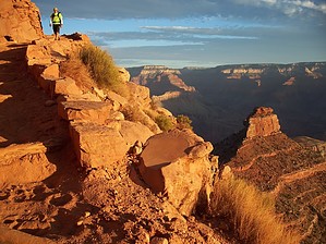
Possibly the best views! by HAZ_Hikebot   Overview OverviewHow would you describe a 4,500' elevation change over 6.5 miles? It's a toe-buster going down and a calf-buster coming out. It's a beautifully maintained trail and a fantastic way to experience the Grand Canyon at its best but you'll soon know if all that training you did was enough. If your finances allow, rent space on a mule to carry your pack and just take a day-pack. This makes for a much more enjoyable trip. History The South Kaibab Trail is a modern route, having been constructed as a means by which park visitors could bypass Ralph Cameron's Bright Angel Trail. Cameron, who owned the Bright Angel Trail and charged a toll to those using it, fought dozens of legal battles over several decades to maintain his business rights. These legal battles inspired the Santa Fe railroad to build its own alternative trail, the Hermit Trail, beginning in 1911 before the National Park Service went on to build the South Kaibab Trail beginning in 1924. In this way, Cameron inadvertently contributed much to the greater network of trails currently available for use by canyon visitors.
Remember the time it takes you to hike into Phantom Ranch, add 50% for good measure and you have an idea of how long it'll take you to get out. Even better, hike down on Kaibab and back out on Bright Angel to experience both trails. Kaibab will probably be the most intense 6.5 miles you'll ever hike. The views are breathtaking as anyone will tell you who's done it. Take 2 pairs of socks, 2 pairs of liners, and change them halfway to give your feet a break and minimize blistering. Moleskin will be worth its weight in gold as well if you're prone to blisters. Keep in mind the temperature change you'll likely encounter as well. During the spring and fall, it'll be cool at the top and hot by the time you reach Phantom. Coming out, you'll have little actual temperature fluctuation as the elevation change offsets the heating of the day which is nice. Someone told me if you can do Piestewa Peak 4 times in one day that's about what Kaibab is like. Sound advice and a good thing to keep in mind when training.
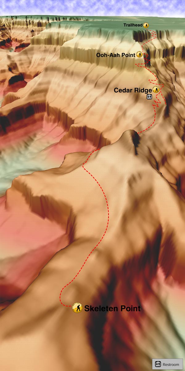
Grand Canyon NPS Details When camping at Bright Angel Campground, many hikers prefer to hike down the South Kaibab Trail and up the Bright Angel Trail. Though the South Kaibab Trail has an almost identical maximum grade compared to the Bright Angel, it is more consistently sloped but does not have water or shade. The hike down South Kaibab Trail typically takes 4-6 hours. The trail begins with a series of tight switchbacks. This is where ice will most likely be encountered during the winter months. After these initial switchbacks, the trail traverses below Yaki Point to the aptly named Ooh Ah Point (the first panoramic view of the canyon) at 0.8-miles. From Ooh Ah Point on, the trail follows the top of a ridgeline and is consequently without shade. Several broad and steeply-plunging switchbacks later, hikers reach Cedar Ridge. There are pit toilets at Cedar Ridge, but no water or emergency phone. From Cedar Ridge, the South Kaibab Trail traverses below O'Neill Butte without a single switchback to Skeleton Point. At three miles from the rim, Skeleton Point is the maximum distance recommended for a day hike. The trail goes directly off the end of Skeleton Point and here, where the trail has been blasted directly out of the limestone cliffs, hikers will encounter the most dramatic sense of exposure. The trail descends rapidly via a series of switchbacks to the Tonto Platform and Tipoff. There are pit toilets and an emergency phone at Tipoff, but no water. For hikers who will be utilizing the Tonto Trail to the east or west, the intersection is located fifty feet or so up-trail from the pit toilets. Below Tipoff, the South Kaibab Trail loosely follows the course of an earlier trail called the Cable Trail (built in 1907 to accommodate access to the old cable car system across the river that existed before the construction of the present suspension bridge). Vestiges of this earlier trail can be seen as the South Kaibab Trail descends toward the Colorado River. Access to Bright Angel Campground is via the black bridge (built in 1921). Water Sources: There is no water on the South Kaibab Trail. From early May to mid-October there is water near the trailhead (from a spigot near the bus stop). Potable water is available year-round at Bright Angel Campground, however, please note that due to occasional pipeline breaks water at Bright Angel Campground is not guaranteed: bringing an alternative form of water treatment, such as iodine tablets or a water filter, is essential. During hot weather, take at least 4 liters of water. Campsites: At-large camping is not permitted on Corridor Trails; visitors must camp in designated campgrounds. Along the South Kaibab Trail, the only camping option is at Bright Angel Campground (CBG) located immediately adjacent to the Colorado River at the bottom of the canyon. Notes: Grand Canyon is, above all else, a place of extremes. It is necessary to take appropriate precautions depending on seasonal variations in trail conditions. During the winter months, the series of tight switchbacks near the top of the South Kaibab Trail will be icy for days or even weeks after a snowstorm. For hikers who insist on entering the canyon from May to September, it is critical to begin hiking well before dawn or in the late afternoon: Success depends upon staying off the trail between 10 in the morning and 3 in the afternoon (average descent time is 4 to 6 hours). Failure to arrive at Bright Angel Campground by 10 in the morning during hot weather can result in ill health or even death; at the very least, it will be a miserable experience. Ascending the South Kaibab Trail in hot weather is not recommended. Carefully study the National Park Service "Hike Smart" pamphlet issued with summer permits and always practice Leave No Trace. Segments to Consider:
Check out the Official Route and Triplogs. Note This is a difficult hike. Arrive fit and prepared or this could get ugly. Leave No Trace and +Add a Triplog after your hike to support this local community. One-Way Notice This hike is listed as One-Way. When hiking several trails on a single "hike", log it with a generic name that describes the hike. Then link the trails traveled, check out the example. | |||||||||||||||||||||||||||||||||||||||||||||||||||||||||||||||||||||||||||||||||||||||||||||||||||||||||||||||||||||||||||||||||||||||||||||||||||||||||||||||||||||||||||||||||||||||||||||||||||||||||||||||||||||||||||||


