Route Editor

| Guide | ♦ | 107 Triplogs | 3 Topics |
details | drive | no permit | forecast | 🔥 route |
stats |
photos | triplogs | topics | location |
| 853 | 107 | 3 |
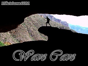
Superstition Pipeline by DavidNLetlet  2026 March Changes 2026 March ChangesThe Carney Spring Trailhead is closed. This hike now begins at the Lost Goldmine TH. It is 0.5 mile longer one-way and 16 feet less AEG. Dubbed the "Wave Cave" by Joe Bartels in 2002. Overview If you are looking for a departure from the usual Peralta to Fremont Saddle, Bluff Springs, or West Boulder Saddle routine, this may be the hike for you. Having said that, there is bushwhacking, boulder-hopping, confusing cairns going the wrong way, NO signage, steep, slippery inclines/descents, loose dirt/gravel, a great cave, and some of the best scenery the Superstition Mountains have to offer. Relaxing day. This is also a great route up to the Superstition Ridgeline. Still interested? Read on. This is a shorter hike out near Peralta. 4.25 miles, at best, but it is a tough little route. It isn't off-trail, but it is a very faint trail (likely dating to the '50s-'60s) that we have been quietly resurrecting over the last year. We recommend long sleeves/pants (and perhaps gloves) due to some catclaw, and the generally overgrown nature of the "trail" in spots. As such, snakes (and other critters) may be present and hard to spot due to the vegetation. In addition, a recent presence of bees has been noted at the cave (similar to those found at Wind Cave at Usery Mountain Regional Park). Stay away from them, and you should be fine, but this may not be your hike if they are a concern for you. Many might find walking sticks/poles helpful on this hike, though they are not a necessity. Hike Begin this hike from the Carney Springs Trailhead and proceed in a northwesterly direction along the old roadbed for about a mile to a fence line that marks the Superstition Wilderness. Look ahead of you and to the right, and pass through the gate into the Wilderness area. Continue up the trail maybe a quarter mile or so and take the faintly marked trail to the left just the other side of the old palo verde tree ( Ironwood ). This spot sometimes has a cairn at it and usually has some rocks laid across the entrance to it. There is an obvious trail at this junction to the left, but it quickly becomes a bit less distinct as you travel it. Just keep your eyes out for the cairns as you go, and continue to follow a general west-northwest direction as you climb ever so gently in a diagonal direction toward a deep wash, which shall become evident upon reaching it in a half-mile or so. At the wash, descend carefully into it along one of the two paths in the area, and proceed in a northerly direction up the wash for some distance (just a couple of tenths of a mile) until you see a rather pointy large boulder to the left of the wash. At this time, you should see the cairns taking you out of the wash to the left. At this point, the real climbing begins. However, it is brief, as you will reach the cave within 5-10 minutes, as you steadily make your way up the embankment on a rather remarkably clear trail considering the route so far. The cave will be visible to you at various points along the route, including a clear view from the trailhead itself. Keep an eye out as you travel towards it, and you should have no issues reaching it the first time out. At the cave, you will find a welcome respite from the climb in the confines of a large deep opening cut into the rock over time that provides ample shade and delightfully cooler temperatures during your visit. Some evidence of man in the form of spray-painted graffiti marks the cave walls in some spots. There is a marvelous wave-shaped rock jutting out of the cave floor that lends itself to great photo opportunities for those interested. Travel back around and in front of the cave and to the west 50 feet or so, and you will find a smaller "guest house" cave next to this one. Each cave provides a great spot to enjoy lunch and overlooks the valley far below to the south. Return the same way, or continue up the wash to the left to reach the Superstition Ridgeline across the Superstitions to the west, or turn to the right (east) to make a loop hike coming down at West Boulder Saddle or continuing to Robber's Roost and Fremont Saddle (or even Cave Trail, if you wish) to add distance, and adventure to this wonderful hike. Gate Policy: If a gate is closed upon arrival, leave it closed after you go through. If it is open, leave it open. Leaving a closed gate open may put cattle in danger. Closing an open gate may cut them off from water. Please be respectful, leave gates as found. The exception is signage on the gate directing you otherwise. Check out the Official Route and Triplogs. Leave No Trace and +Add a Triplog after your hike to support this local community. | |||||||||||||||||||||||||||||||||||||||||||||||||||||||||||||||||||||||||||||||||||||||||||||||||||||||||||||||||||||||||||||||||||||||||||||||||||||||||||||||||||||||||||||||||||||||||||||||||||||||||||||||||