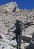
Hiking this trail from Flat Iron towards Carney, we came across a section that seemed pretty impassable - at least for some members of our group. The section is between Hieroglyphics Canyon and Superstition Peak (Point 161 in the official route file). It's a narrow climb and there is cairns there leading me to believe we were on the correct path, but the climb seemed more difficult than anything on Siphon Draw up to Flat Iron, which makes me think it's not the correct trail.
I have included a picture from Google Earth showing and overlay of the Official Route file from this site. The red arrow shows exactly where the narrow slot is.
Can anybody help?
@runboy2
I am not an expert on ridgeline, but I think you were on right track, I seem to remember the spot..I took note as I was assessing whether the dog could do it..although, I could have been off the route myself..
It appears from the distant photo that you refer to that short 'chute' that is encountered on the Ridgeline hike.
In the 6-7 times I have hiked it I have always used that chute whether Carney-> Flatiron or vise-versa. It may appear daunting to some at first, but it's no biggie, really.
"The censorship method ... is that of handing the job over to some frail and erring mortal man, and making him omnipotent on the assumption that his official status will make him infallible and omniscient."
George Bernard Shaw
I only got unnerved in one spot on Ridgeline but it wasn't in that chute or on Flatiron ascent. It was a sloping area of slick rock with scree on it with a drop at the end of the rock face. I've tried to locate it on Google Earth but cannot.
Follow me on Instagram: hikingjason
"It's not the mountains that we conquer, but ourselves"
We saw a group of hikers earlier coming from the Carney side that brought a dog with them. Just don't see how they would've managed to get down that chute with the dog. From other descriptions it seems like this 'chute' is supposed to be easier than Siphon. I could climb it but we had a couple of hikers in the group not able to and they didn't have any problems with Siphon.
While I wouldn't recommend it for most dogs, there are some pretty hard core desert hikers among the canine crowd who can do it with just a little bit of help from the nearest biped.
I'm not sure what my spirit animal is, but I'm confident it has rabies.
Chumley is right never underestimate the pooches On my last trip to the Supes I was chuckling as I watched a group using rope to reach the Rogers Canyon Ruins...a climb my dog has made several times on his own..
skillpore wrote:Ive seen people take two different ways in that area. One right up the short climb, and the other around to the left of the face/wall where your arrow is.
What you may not have seen is people Doubling Back after trying to go to the Left...There appears to be a "Use Trail" that is fairly Deceiving that takes you past the Saddle and down to the Left of the Chute...It pretty much disappears after 500 Feet and it gets pretty sketchy trying to continue past that....Van and I decided that it wasn't doable and Doubled Back to the Chute...The Chute was way Easier....
Lifeis not a journey to the grave with the intention of arriving safely in a pretty & well preserved body, but rather to skid in broadside, totally worn out & proclaiming,"Wow What a Ride!"
skillpore wrote:Ive seen people take two different ways in that area. One right up the short climb, and the other around to the left of the face/wall where your arrow is.
What you may not have seen is people Doubling Back after trying to go to the Left...There appears to be a "Use Trail" that is fairly Deceiving that takes you past the Saddle and down to the Left of the Chute...It pretty much disappears after 500 Feet and it gets pretty sketchy trying to continue past that....Van and I decided that it wasn't doable and Doubled Back to the Chute...The Chute was way Easier....
Yes, we tried going left as well, but like you said, that seemed to be a bad option.
Still not convinced we were at the right chute. It kind of looked like the last picture chumley posted (The one from flatiron, just without steps, so you had to climb between two walls to get up.
Guess I will just have to go up there again before it gets too hot
skillpore wrote:Ive seen people take two different ways in that area. One right up the short climb, and the other around to the left of the face/wall where your arrow is.
What you may not have seen is people Doubling Back after trying to go to the Left...There appears to be a "Use Trail" that is fairly Deceiving that takes you past the Saddle and down to the Left of the Chute...It pretty much disappears after 500 Feet and it gets pretty sketchy trying to continue past that....Van and I decided that it wasn't doable and Doubled Back to the Chute...The Chute was way Easier....
Every single time I go left..and always have to back track. You'd think I'd learn one of these times.
friendofThundergod wrote:@runboy2
I am not an expert on ridgeline, but I think you were on right track, I seem to remember the spot..I took note as I was assessing whether the dog could do it..although, I could have been off the route myself..
That is the one spot I was wondering if I would need a sling to get Rowdy over it.
runboy2 wrote:Still not convinced we were at the right chute. It kind of looked like the last picture chumley posted (The one from flatiron, just without steps, so you had to climb between two walls to get up.
That's it...Basically, it's neither Right or Left of the Saddle. If you walk a pretty straight line down the Middle of the Saddle going South, you run right into it...At a Glance, it doesn't seem Feasible and I think that why so many mistakenly go Left (along with the Fact that it appears that the Trail goes that way) But it really is the only way and it's not as bad as it looks... Did any of your Party try to go up it???
Lifeis not a journey to the grave with the intention of arriving safely in a pretty & well preserved body, but rather to skid in broadside, totally worn out & proclaiming,"Wow What a Ride!"
I've taken my dog through there. Had to help her. There's a little ledge on the left (heading towards 5057) that gives you a relatively easy way through. One long step to get around a corner.
runboy2 wrote:Still not convinced we were at the right chute. It kind of looked like the last picture chumley posted (The one from flatiron, just without steps, so you had to climb between two walls to get up.
That's it...Basically, it's neither Right or Left of the Saddle. If you walk a pretty straight line down the Middle of the Saddle going South, you run right into it...At a Glance, it doesn't seem Feasible and I think that why so many mistakenly go Left (along with the Fact that it appears that the Trail goes that way) But it really is the only way and it's not as bad as it looks... Did any of your Party try to go up it???
Yes, and we had one in the group who couldn't do it. Was just thinking there may have been another route we had missed, but I guess this was it. We didn't mess with it too long since we were running out of time and thought we were on the wrong track.
skillpore wrote:Ive seen people take two different ways in that area. One right up the short climb, and the other around to the left of the face/wall where your arrow is.
What you may not have seen is people Doubling Back after trying to go to the Left...There appears to be a "Use Trail" that is fairly Deceiving that takes you past the Saddle and down to the Left of the Chute...It pretty much disappears after 500 Feet and it gets pretty sketchy trying to continue past that....Van and I decided that it wasn't doable and Doubled Back to the Chute...The Chute was way Easier....
Yes, we tried going left as well, but like you said, that seemed to be a bad option.
Still not convinced we were at the right chute. It kind of looked like the last picture chumley posted (The one from flatiron, just without steps, so you had to climb between two walls to get up.
Guess I will just have to go up there again before it gets too hot
I know where you are talking about. I remember wondering whether the scramble we took was the right path either. Here's how I described it in my triplog: "Cairns run a bit rampant from this section over to 5057, especially as you make the ascent up to the point where you skirt around 5057. This makes it a bit difficult to figure out which path is the "best" to take. In the end, they all seemed to get back to the right place. There was a bit more scrambling (and elevation gain) in this section than our crew had mentally prepared for."
skillpore wrote:I belive this video shows the chute. Looks like I went to the left?. I was coming from the east back to my pack. Where I came up from heiro. https://www.youtube.com/watch?v=ajzpO6ffVy4
The mentioned chute is further SE on the ridgeline as far as I can tell from your video.
 Route Editor