 Route Editor

What can you tell me about the condition of Ash Creek Bypass pre 2017 Frye Fire? We are working with the USFS and Fort Grant Crew to consider reopening it but haven't full scouted it down to the Slick Rock View Area. Was this a quality route that you think could be restored? I see that Skyislander18, RWStorm and Pivo were some of the most "recent" to hike the trail.
Cheers!
Ash Creek Trail Bypass #307A, AZ :: Question by gordee151
Moderator: HAZ - Moderators
Linked Area, etc none
-
 gordee151Guides: 0 | Official Routes: 1Triplogs Last: 905 d | RS: 0Water Reports 1Y: 0 | Last: never
 - Joined: Mar 29 2022 2:00 pm
- City, State: Tucson, AZ
Ash Creek Trail Bypass #307A, AZ :: Question by gordee151
Sonoran Desert Mountain Bicyclists
Mt Graham Volunteer Trail Work Coordinator
Want to volunteer? Email: communications@sdmb.org
Instagram @sdmb_mtb
Mt Graham Volunteer Trail Work Coordinator
Want to volunteer? Email: communications@sdmb.org
Instagram @sdmb_mtb
contribute to this member driven resource
ie: RS > Save/Share after hikes 

-
 RedRoxx44Guides: 5 | Official Routes: 0Triplogs Last: 6 d | RS: 0Water Reports 1Y: 0 | Last: 6,521 d
 - Joined: Feb 15 2003 8:07 am
- City, State: outside, anywhere
Re: Ash Creek Trail Bypass #307A, AZ :: Question by gordee151
Well, don't know pre fire but I hiked to the falls in 2019 using what was left of the original trail and just the scoured canyon. I attempted to locate the bypass route but did not get very far before it seemed totally brushed out. I thought it should be easier than what I had done, but decided to go back the way I came. I would think if it was restored it would definitely be an improvement over the rock scrambling and deep banks you have to negotiate now for most hikers. Past the slickrock area the original trail is intact but full of brush and wasn't bad at the viewpoint of the big falls.
contribute to this member driven resource
ie: RS > Save/Share after hikes
-
 chumleyGuides: 94 | Official Routes: 239Triplogs Last: 6 d | RS: 73Water Reports 1Y: 95 | Last: 4 d
 - Joined: Sep 18 2002 8:59 am
- City, State: Tempe, AZ
Re: Ash Creek Trail Bypass #307A, AZ :: Question by gordee151
From my 9/2/18 [ photoset ]
I think it’s a prime candidate for some trail work to get it back into shape.
Of course it’s sure to have grown over more in the ensuing years, but the tread was there and wasn’t too badly damaged.With my travel going so slowly, I opted for the bypass route when I came to it, which seemed to be a better option. There wasn't much fire on this hillside, but the tread is still eroded, and the lack of use for two years has made it quite overgrown. But rehabilitating this bypass won't be too difficult.
I think it’s a prime candidate for some trail work to get it back into shape.
I'm not sure what my spirit animal is, but I'm confident it has rabies.
contribute to this member driven resource
ie: RS > Save/Share after hikes
-
gordee151Guides: 0 | Official Routes: 1Triplogs Last: 905 d | RS: 0Water Reports 1Y: 0 | Last: never
- Joined: Mar 29 2022 2:00 pm
- City, State: Tucson, AZ
Re: Ash Creek Trail Bypass #307A, AZ :: Question by gordee151
@chumley
Hi Chumley, Thanks a bunch. Saw your photos and the caption that stated back in 2018 you thought a crew might be able to punch through the bypass in a week. Would you mind emailing me at communications@sdmb.org? I'd like to ask some follow up questions and perhaps connect you with someone that may scout it next week.
Hi Chumley, Thanks a bunch. Saw your photos and the caption that stated back in 2018 you thought a crew might be able to punch through the bypass in a week. Would you mind emailing me at communications@sdmb.org? I'd like to ask some follow up questions and perhaps connect you with someone that may scout it next week.
Sonoran Desert Mountain Bicyclists
Mt Graham Volunteer Trail Work Coordinator
Want to volunteer? Email: communications@sdmb.org
Instagram @sdmb_mtb
Mt Graham Volunteer Trail Work Coordinator
Want to volunteer? Email: communications@sdmb.org
Instagram @sdmb_mtb
contribute to this member driven resource
ie: RS > Save/Share after hikes
-
 nonotGuides: 107 | Official Routes: 108Triplogs Last: 111 d | RS: 0Water Reports 1Y: 9 | Last: 110 d
 - Joined: Nov 18 2005 11:52 pm
- City, State: Phoenix, AZ
Re: Ash Creek Trail Bypass #307A, AZ :: Question by gordee151
I hiked it pre-fire in 2011. Described from the bottom up - Basically, rather than follow right next to the stream, it did a switchback to get perhaps a hundred or so feet away from the creek then followed a somewhat steep uphill to a small knob, for there it was did a few ups and downs overall staying fairly level until it intersected Ash Creek trail back up above the slickrock area. It meandered around a few bushes but overall was in fairly good shape and not overgrown in 2011. In 2011 it had been impacted by a previous fire (2005?) that had killed off many of the trees near the trail and left it fairly treeless near the bottom part. Writeup and 2011 GPS route is here:
[ Ash Creek Trail Bypass #307A ]
The old topo maps show it swinging way uphill to the ridgeline, but the GPS route I posted to that trail description should help you find the original trail, or at least what's left of it. I haven't hiked it since the fire.
[ Ash Creek Trail Bypass #307A ]
The old topo maps show it swinging way uphill to the ridgeline, but the GPS route I posted to that trail description should help you find the original trail, or at least what's left of it. I haven't hiked it since the fire.
http://hikearizona.com/garmin_maps.php
Hike Arizona it is full of sharp, pointy, ankle-twisting, HAZmaster crushing ROCKS!!
Hike Arizona it is full of sharp, pointy, shin-stabbing, skin-shredding plants!
Hike Arizona it is full of striking, biting, stabbing, venomous wildlife!
Hike Arizona it is full of sharp, pointy, ankle-twisting, HAZmaster crushing ROCKS!!
Hike Arizona it is full of sharp, pointy, shin-stabbing, skin-shredding plants!
Hike Arizona it is full of striking, biting, stabbing, venomous wildlife!
contribute to this member driven resource
ie: RS > Save/Share after hikes
-
gordee151Guides: 0 | Official Routes: 1Triplogs Last: 905 d | RS: 0Water Reports 1Y: 0 | Last: never
- Joined: Mar 29 2022 2:00 pm
- City, State: Tucson, AZ
Re: Ash Creek Trail Bypass #307A, AZ :: Question by gordee151
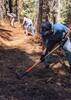
Ft Grant Crew has made it down below the Mill Site. They tuned up the blow out crossings best they could and re-established single track along the drainage headed down to the bypass. Bypass is up next but wanted to get some insight before scouting and flagging. The scouting may happen before it gets too snowy this season. Questionable if they'll have time to complete the work. If it stays dry the next couple of weeks, then maybe. If not, then they'll work stuff lower down the mtn. Thank you all!!
- Attachments
-
-
-
-
Last edited by gordee151 on Nov 27 2023 9:07 pm, edited 3 times in total.
Sonoran Desert Mountain Bicyclists
Mt Graham Volunteer Trail Work Coordinator
Want to volunteer? Email: communications@sdmb.org
Instagram @sdmb_mtb
Mt Graham Volunteer Trail Work Coordinator
Want to volunteer? Email: communications@sdmb.org
Instagram @sdmb_mtb
contribute to this member driven resource
ie: RS > Save/Share after hikes
-
nonotGuides: 107 | Official Routes: 108Triplogs Last: 111 d | RS: 0Water Reports 1Y: 9 | Last: 110 d
- Joined: Nov 18 2005 11:52 pm
- City, State: Phoenix, AZ
Re: Ash Creek Trail Bypass #307A, AZ :: Question by gordee151
Awesome, please convey our thanks to the trail maintenance crews - that is hard work!
http://hikearizona.com/garmin_maps.php
Hike Arizona it is full of sharp, pointy, ankle-twisting, HAZmaster crushing ROCKS!!
Hike Arizona it is full of sharp, pointy, shin-stabbing, skin-shredding plants!
Hike Arizona it is full of striking, biting, stabbing, venomous wildlife!
Hike Arizona it is full of sharp, pointy, ankle-twisting, HAZmaster crushing ROCKS!!
Hike Arizona it is full of sharp, pointy, shin-stabbing, skin-shredding plants!
Hike Arizona it is full of striking, biting, stabbing, venomous wildlife!
contribute to this member driven resource
ie: RS > Save/Share after hikes
-
 PrestonSandsGuides: 170 | Official Routes: 86Triplogs Last: 501 d | RS: 0Water Reports 1Y: 0 | Last: 508 d
 - Joined: Apr 12 2004 10:59 pm
- City, State: Tucson, AZ
- Contact:
Re: Ash Creek Trail Bypass #307A, AZ :: Question by gordee151
Thank you gordee!!!
"…you never know when a hike might break out" -Jim Gaffigan
contribute to this member driven resource
ie: RS > Save/Share after hikes