 Route Editor

This is in the preliminary planning stage.... But was thinking about a 3rd trip up to quartz peak.
Obviously it wouldnt be for several month, until the weather cools down.
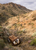
For those not familiar, Quatrz peak is in the Estrella mountians and considered remote and difficult. TrailDEX has a good description of the trail.
Basically its 2,500 feet in less than 3 miles one way.
Im just planting seeds today to see if anything grows.
Discuss
3rd annual quartz peak trek - Sat Dec 13th 2003
Moderators: HAZ Group Coordinators, HAZ - Moderators
Linked Guides none
-
 CakewalkGuides: 1 | Official Routes: 0Triplogs Last: 8,576 d | RS: 0Water Reports 1Y: 0 | Last: never
 - Joined: Feb 03 2002 11:26 pm
- City, State: Glendale, AZ
3rd annual quartz peak trek
< Insert Witty Remark here >
contribute to this member driven resource
ie: RS > Save/Share after hikes 

-
 Marc LaBelleGuides: 0 | Official Routes: 0Triplogs Last: 6,967 d | RS: 0Water Reports 1Y: 0 | Last: never
 - Joined: Oct 02 2003 4:06 pm
- City, State: Tempe, AZ
Cakewalk, I can do the second weekend as well. And, if I recall, someone stated that a clearance vehicle is preferred. I have an F150 4x4. The pretty kind. you know, the ones that say 4x4, but have never seen any action. Count me in.
From all the prior descriptions, I am guessing that I should cancel X-mas party plans that night due to foreseen muscle fatigue??????
Marc
From all the prior descriptions, I am guessing that I should cancel X-mas party plans that night due to foreseen muscle fatigue??????
Marc
contribute to this member driven resource
ie: RS > Save/Share after hikes
-
 HAZ_HikebotGuides: 989 | Official Routes: 3523Triplogs Last: none | RS: 0Water Reports 1Y: 0 | Last: 688 d
 - Joined: Nov 20 1996 12:00 pm
- City, State: HAZ, TrailDEX
- Contact:
contribute to this member driven resource
ie: RS > Save/Share after hikes
-
 chihiggsGuides: 0 | Official Routes: 0Triplogs Last: 7,688 d | RS: 0Water Reports 1Y: 0 | Last: never
 - Joined: Apr 11 2002 9:33 am
- City, State: Gilbert, AZ
"foreseen muscle fatigue"  I like that and honestly, will probably steal it...
Anyhow, I am also in for the 13th. I have an old Blazer that'll be going; no back seat so alot of people can actually fit in the back. I think I remember Cakewalk mentioning meeting somewhere near the road to the trail before hand so when we get this solidified count on being able to use my truck too... Count me in!!
What's our count up to now, 5-7? Just curious.
Higgs
contribute to this member driven resource
ie: RS > Save/Share after hikes
-
CakewalkGuides: 1 | Official Routes: 0Triplogs Last: 8,576 d | RS: 0Water Reports 1Y: 0 | Last: never
- Joined: Feb 03 2002 11:26 pm
- City, State: Glendale, AZ
contribute to this member driven resource
ie: RS > Save/Share after hikes
-
 MtnGeekGuides: 9 | Official Routes: 0Triplogs Last: 2,127 d | RS: 0Water Reports 1Y: 0 | Last: never
 - Joined: May 01 2002 11:09 am
- City, State: Denver, CO
contribute to this member driven resource
ie: RS > Save/Share after hikes
-
 AZBrad123Guides: 0 | Official Routes: 0Triplogs Last: 7,959 d | RS: 0Water Reports 1Y: 0 | Last: never
 - Joined: Oct 27 2003 8:59 am
- City, State: Phoenix, AZ
Defintely Interested
Hey All, sounds like a great hike, would love to join. The second Saturday of December works great too.
I have a 4x4 jeep cherokee that can take a couple of xtra people.
I have a 4x4 jeep cherokee that can take a couple of xtra people.
contribute to this member driven resource
ie: RS > Save/Share after hikes
-
 whereveriroamGuides: 8 | Official Routes: 0Triplogs Last: 910 d | RS: 0Water Reports 1Y: 0 | Last: 917 d
 - Joined: Mar 07 2003 3:14 pm
- City, State: Apache Junction, AZ
contribute to this member driven resource
ie: RS > Save/Share after hikes
-
MtnGeekGuides: 9 | Official Routes: 0Triplogs Last: 2,127 d | RS: 0Water Reports 1Y: 0 | Last: never
- Joined: May 01 2002 11:09 am
- City, State: Denver, CO
contribute to this member driven resource
ie: RS > Save/Share after hikes
-
CakewalkGuides: 1 | Official Routes: 0Triplogs Last: 8,576 d | RS: 0Water Reports 1Y: 0 | Last: never
- Joined: Feb 03 2002 11:26 pm
- City, State: Glendale, AZ
In response to Steven's reply:
From Phoenix head west on I-10 towards California. Take the Estrella Parkway exit and head south. Continue 8.2 miles to Elliot Road. Take a right and the gas station will be on the right hand side. From that point we are still around 20 mile from the trail head.
Looks like we are going on Saturday, December 13th. Lets plan on 9am?
I will need a ride from the gas station as my car is not worthy of such a trek.
< Insert Witty Remark here >
contribute to this member driven resource
ie: RS > Save/Share after hikes
-
chihiggsGuides: 0 | Official Routes: 0Triplogs Last: 7,688 d | RS: 0Water Reports 1Y: 0 | Last: never
- Joined: Apr 11 2002 9:33 am
- City, State: Gilbert, AZ
contribute to this member driven resource
ie: RS > Save/Share after hikes
-
CakewalkGuides: 1 | Official Routes: 0Triplogs Last: 8,576 d | RS: 0Water Reports 1Y: 0 | Last: never
- Joined: Feb 03 2002 11:26 pm
- City, State: Glendale, AZ
contribute to this member driven resource
ie: RS > Save/Share after hikes
-
 azhiker96Guides: 0 | Official Routes: 0Triplogs Last: 1,177 d | RS: 2Water Reports 1Y: 0 | Last: never
 - Joined: Feb 03 2002 10:17 am
- City, State: Gilbert, AZ
I took a small group to Quartz peak yesterday. There's some construction on Estrella Parkway. The I-10 westbound exit for Estrella Parkway is closed. We went on down a mile, exited and then worked our way back to the parkway. The entrance ramps from Estrella Parkway to I-10 were open. Just an FYI. Also, there is a pit toilet at the trailhead but no TP. Not a problem to a prepared hiker. We saw a few hawks and one Kestrel. The dirt road is in great shape. Medium to high clearance is all you need. One of our group had a close experience of the cholla kind. Just one bud in the calf. We helped de-spine a guy who had fallen and managed to get 3 buds in his hand. It was a great day for a hike which we followed up with a trip to the hot springs at Tonopah. Mmmmmmm.
"Sometimes I wonder whether the world is being run by smart people who are putting us on or by imbeciles who really mean it."
~ Mark Twain
~ Mark Twain
contribute to this member driven resource
ie: RS > Save/Share after hikes
-
chihiggsGuides: 0 | Official Routes: 0Triplogs Last: 7,688 d | RS: 0Water Reports 1Y: 0 | Last: never
- Joined: Apr 11 2002 9:33 am
- City, State: Gilbert, AZ
contribute to this member driven resource
ie: RS > Save/Share after hikes
-
whereveriroamGuides: 8 | Official Routes: 0Triplogs Last: 910 d | RS: 0Water Reports 1Y: 0 | Last: 917 d
- Joined: Mar 07 2003 3:14 pm
- City, State: Apache Junction, AZ
contribute to this member driven resource
ie: RS > Save/Share after hikes
-
 Davis2001r6Guides: 6 | Official Routes: 14Triplogs Last: 5,908 d | RS: 0Water Reports 1Y: 0 | Last: never
 - Joined: Dec 06 2003 3:27 am
- City, State: Bordeaux, France
- Contact:
contribute to this member driven resource
ie: RS > Save/Share after hikes
-
MtnGeekGuides: 9 | Official Routes: 0Triplogs Last: 2,127 d | RS: 0Water Reports 1Y: 0 | Last: never
- Joined: May 01 2002 11:09 am
- City, State: Denver, CO
contribute to this member driven resource
ie: RS > Save/Share after hikes
-
CakewalkGuides: 1 | Official Routes: 0Triplogs Last: 8,576 d | RS: 0Water Reports 1Y: 0 | Last: never
- Joined: Feb 03 2002 11:26 pm
- City, State: Glendale, AZ
contribute to this member driven resource
ie: RS > Save/Share after hikes
-
CakewalkGuides: 1 | Official Routes: 0Triplogs Last: 8,576 d | RS: 0Water Reports 1Y: 0 | Last: never
- Joined: Feb 03 2002 11:26 pm
- City, State: Glendale, AZ
contribute to this member driven resource
ie: RS > Save/Share after hikes
-
MtnGeekGuides: 9 | Official Routes: 0Triplogs Last: 2,127 d | RS: 0Water Reports 1Y: 0 | Last: never
- Joined: May 01 2002 11:09 am
- City, State: Denver, CO
Yeah, 5 of us showed up. We left the gas station at 9:30. Next time you use this as the meeting point add a few more details about it. I did not see the gas station, it just looked like a market place to me and I passed it and kept on going for more than a mile. I turned around and decided to see if that was it. It's a weird gas station.
I took some pics but wont have them developed for awhile. It was a great hike. Too bad you could not make it Cakewalk. It was not as hard as i anticipated, but it was good to help me get back into shape, mainly for the 4 peaks next week.
I took some pics but wont have them developed for awhile. It was a great hike. Too bad you could not make it Cakewalk. It was not as hard as i anticipated, but it was good to help me get back into shape, mainly for the 4 peaks next week.
Mountains are there to be hiked!
contribute to this member driven resource
ie: RS > Save/Share after hikes
-
CakewalkGuides: 1 | Official Routes: 0Triplogs Last: 8,576 d | RS: 0Water Reports 1Y: 0 | Last: never
- Joined: Feb 03 2002 11:26 pm
- City, State: Glendale, AZ
contribute to this member driven resource
ie: RS > Save/Share after hikes