My wife and I will be making a trip to these parks very soon. I was wondering if any of you had any great recommendations. We are comfortable hiking 5-8 miles in intermediate type stuff. I am not sure of the elevation of these parks so that might also be a factor to consider. We have logged a little over 250 miles on Phoenix area trails in the last 4 months or so.
I will also be driving a 4x4, so any back country roads you might know of for photography would be appreciated as well.
I know this is off topic for an Arizona board. I hoped I don't get slapped on the back of the hand with a ruler.
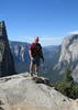
For the first time visitor to Zion, I would recommend Angels Landing hike which takes in Walters Wiggles. Its a popular hike offering great views without getting to technical.
It's best for a man to remain silent and be thought a fool, than to open his mouth and remove all doubt.
--Mark Twain
I spent a month in the area last summer exploring hikes,trails and backcountry roads and just scratched the surface. Be sure to stop at the visitor center for Escalante as you enter Kanab from the east-inquire about backcountry conditions, suggestions and maps(there is a great backcountry way to get to Bryce from Kanab via Johnson Canyon Rd,which is east about 5 miles from Kanab) Also stop at the visitor center in town(Kanab) its on the left as you're proceeding thru town to the north. A ton of ideas for adventures.
It's best for a man to remain silent and be thought a fool, than to open his mouth and remove all doubt.
--Mark Twain
My wife's grandfather Leo A. Snow after surveying the area of Zions National Park recommended to the then president of the United States that it become a National Park. For years no mention of his successfull efforts were displayed at the Park's Visitor Center but now they tell his story and display his brass surveying equipment. Please take a picture of the display so we can all see it. Thanks much...
A man's body may grow old, but inside his spirit can still be as young and restless as ever.
- Garth McCann from the movie Second Hand Lions
nickfraley wrote:The hike to Observation Point in Zion is also very nice from what I recall. Great view of the canyon from the east rim.
YES!! Hike to Observation Point and look down on all the suckers crowding Angel's Landing. Observation Point easily provides the most commanding view of the Virgin River in Zion. Well worth the trek!
"I'm not a vegetarian because I love animals; I'm a vegetarian because I hate plants." A. Whitney Brown
In Zion. As was mentioned, Angel's Landing can be crowded, but start early (sunrise or near it) and you'll avoid that, at least on the way up. It really is worth doing...a very scenic, interesting route. Didn't do Observation Point, but heard it's great as well. Emerald Pools is nice for a shorter walk, but not as scenic as Angel's Landing by any stretch. Also consider doing a bit of the Narrows if weather permits. Not sure what conditions are like at this time of year...the river may be too high and/or cold, but if not go up canyon at least a couple miles. It's awesome.
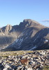
In Bryce. Two fantastic day hikes here which would be at the long end of your desired range distance-wise, but aren't particularly difficult. The first is Fairyland Loop. Much less crowded than some of the more popular trails in the park, but every bit as scenic. The second is a combination of Queen's Garden-Navajo-Peekaboo trails into one loop. This hike is fantastic, but crowded. Again, just start fairly early and you'll beat most of the tourist crowd.
You might want to check into a permit for the Subway, go in the bottom instead of the canyoneering route from the top. Very interesting photography, as long as the water is clear. This is in Zion.
The Kolob section of Zion is usually less crowded and offers some big cliff views and a large arch for those willing to take the time and effort to get there.
Just a personal preference---I think Zion offers a little more than Bryce although both are worth visiting.
David I can't wait to see your pictures! Wife and I made the trip last year. Look into Tower Bridge hike in Bryce. It's off the main rim, but once you get a mile down you won't see many people. As I recall it was about 4 miles RT. Good views of Bryce from the bottom up rather than the rim down. If you do make it to Capital Reef we did a short 2 mile hike called Hickman Natural Bridge. We hit an unusual hot week (3rd week in June) and found ourselves going out early for short hikes. In Zion Canyon Visitors center area, at the end of the bus/tram ride is an area called 'The Narrows'. You can walk up the river (1-3 feet deep). It was my first experience with canyonerring. Great place to get a taste. Bring shoes/sandals you use to walk in the river. You're going to love this trip!
Brian
Monday, Tuesday, Wednesday, Thursday, Friday, Saturday......there is no SOMEDAY!
Kolob section of Zion is beautiful. There's a couple hikes from Zion and Bryce here on HAZ (just have to switch the traildex index to UT). Peek-A-Boo is great in Bryce, though often crowded, and with mules on the trail. Navajo-Queen's Garden (as suggested above) is nice too. Altitude is generally going to be a bigger issue in Bryce, where you're starting from 8000', than Zion, where most of the trails start from the valley floor, at around 3500'-4000- (unless you're going to drop in the east Rim or Wildcat trails from the top). Both are nice, but are very different as well.
"The only thing we did was wrong was staying in the wilderness to long...the only thing we did was right was the day we started to fight..."
-Old Spiritual
My book, The Marauders on Lulu and Amazon
I'm back. Had a wonderful trip. In Zion we got up early and hiked up to Scouts Lookout. I determined that my knees wouldn't let me do the trip all the way to the top of Angel's Landing. It was a beautiful 4 mile hike though with around 1200 ft of elevation gain as I recall. Beautiful views. We hiked the river trail to the "Narrows" but there was too much water running and they were not issuing permits to hike in the narrows. We also hiked the lower, middle and upper emerald pools. That was nice but this trail was far busier than Angel's Landing. I think the warnings on Angel's Landing scares a lot of people away. We also made a drive over to Kolob on a very cold and windy day. It was 50 mph winds so we didn't hike that day.
In Bryce we hiked the Queen's Garden/Navajo Loop as soon as we got there. Holy Cow!!!!! What an incredible place. The next morning it was 26 degrees and 40 mph winds. We weren't prepared for that so it ended our hiking and we came home a day early by driving through Cotton Wood Canyon. There was a nice slot canyon there that we wanted to hike, but again....WAY to cold to hike in my shorts. Next time I will be more prepared for possible cold weather.
Silly me...I didn't know that Bryce was so high.
Over all, it was a wonderful experience and we will definitely be back. Soon!
Thanks everyone for your kind suggestions.
Last edited by davidanthonyporter on May 04 2008 8:05 pm, edited 1 time in total.
Glad you had a good time! Yeah, Bryce is pretty high up there, especially compared to Scottsdale. Its definitely a fun part of Utah to explore!
"The only thing we did was wrong was staying in the wilderness to long...the only thing we did was right was the day we started to fight..."
-Old Spiritual
My book, The Marauders on Lulu and Amazon
 Route Editor