 Route Editor

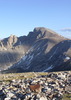
We'll take JF Trail to Tortilla Pass, down Rogers to overnight near Angel Basin. The next morning we'll take Frog Tanks to Fish Creek, take the creekbed off-trail back to the car.
Maybe a gander at Miller Grave, or the lost dutchman mine jr on the first day. Second day we'll have our plate full with fish creek.
Depending on the mood and ability of the group we can either start and end from Tortilla Ranch or do the full upper fish creek all the way to the Apache Trail.
JF/Fish Creek Loop Nov 8-9
Moderators: HAZ Group Coordinators, HAZ - Moderators
Linked Guides • JF Trail to Tortilla Pass, AZ ♦ • Rogers Canyon - JF Trail Loop, AZ ♦ • Fish Creek Canyon - Upper Bridge, AZ
-
 nonotGuides: 107 | Official Routes: 108Triplogs Last: 70 d | RS: 0Water Reports 1Y: 9 | Last: 69 d
 - Joined: Nov 18 2005 11:52 pm
- City, State: Phoenix, AZ
JF/Fish Creek Loop Nov 8-9
http://hikearizona.com/garmin_maps.php
Hike Arizona it is full of sharp, pointy, ankle-twisting, HAZmaster crushing ROCKS!!
Hike Arizona it is full of sharp, pointy, shin-stabbing, skin-shredding plants!
Hike Arizona it is full of striking, biting, stabbing, venomous wildlife!
Hike Arizona it is full of sharp, pointy, ankle-twisting, HAZmaster crushing ROCKS!!
Hike Arizona it is full of sharp, pointy, shin-stabbing, skin-shredding plants!
Hike Arizona it is full of striking, biting, stabbing, venomous wildlife!
contribute to this member driven resource
ie: RS > Save/Share after hikes 

-
 te_waGuides: 3 | Official Routes: 0Triplogs Last: 1,855 d | RS: 2Water Reports 1Y: 0 | Last: 2,054 d
 - Joined: Aug 22 2003 9:16 pm
- City, State: Mesa
Re: JF/Fish Creek Loop Nov 8-9
well, that is if you refer to rock bass and sand trout as fish.. not to say that there are platefulls of fish in fish creek...nonot wrote:Second day we'll have our plate full with fish creek.
Im curious tho, how will we get from tortilla trailhead back to the car if we end up on the az88 near fish creek bridge?
looking at the map i was assuming we were going to take the canyon near the start of (upper) fish creek directly south, that would put us on the tortilla ranch road about .8 mile from the trailhead. Unless of course we use 4x4 then we leave the truck right at that spot. have you seen the canyon on the map that im referring to?
squirrel!
contribute to this member driven resource
ie: RS > Save/Share after hikes
-
nonotGuides: 107 | Official Routes: 108Triplogs Last: 70 d | RS: 0Water Reports 1Y: 9 | Last: 69 d
- Joined: Nov 18 2005 11:52 pm
- City, State: Phoenix, AZ
Re: JF/Fish Creek Loop Nov 8-9
If we start from Apache trail someone would have to walk up Fish Creek Hill to retrieve the vehicle. It only adds an hour the first day, the second day it adds a few due to the canyoneering 
Else if we start from Tortilla Ranch we'd leave the canyon at it's closest point to the ranch and make a beeline back.
Else if we start from Tortilla Ranch we'd leave the canyon at it's closest point to the ranch and make a beeline back.
http://hikearizona.com/garmin_maps.php
Hike Arizona it is full of sharp, pointy, ankle-twisting, HAZmaster crushing ROCKS!!
Hike Arizona it is full of sharp, pointy, shin-stabbing, skin-shredding plants!
Hike Arizona it is full of striking, biting, stabbing, venomous wildlife!
Hike Arizona it is full of sharp, pointy, ankle-twisting, HAZmaster crushing ROCKS!!
Hike Arizona it is full of sharp, pointy, shin-stabbing, skin-shredding plants!
Hike Arizona it is full of striking, biting, stabbing, venomous wildlife!
contribute to this member driven resource
ie: RS > Save/Share after hikes
-
te_waGuides: 3 | Official Routes: 0Triplogs Last: 1,855 d | RS: 2Water Reports 1Y: 0 | Last: 2,054 d
- Joined: Aug 22 2003 9:16 pm
- City, State: Mesa
Re: JF/Fish Creek Loop Nov 8-9
well then, a shuttle may be in order. If we only take 1-2 vehicles as normal, there should be parking at the bridge- provided we get there before 9am. That just leaves the issue of a) we need 2 4x4s or b) we walk 3 extra miles on day 1
anyway, its your hike, your call
anyway, its your hike, your call
squirrel!
contribute to this member driven resource
ie: RS > Save/Share after hikes
-
 wallyfrackGuides: 0 | Official Routes: 6Triplogs Last: 2 d | RS: 0Water Reports 1Y: 2 | Last: 140 d
 - Joined: Mar 11 2003 7:33 pm
- City, State: AZ
Re: JF/Fish Creek Loop Nov 8-9
Did someone say 4x4?
contribute to this member driven resource
ie: RS > Save/Share after hikes
-
 SuperstitionGuyGuides: 0 | Official Routes: 0Triplogs Last: 1,785 d | RS: 0Water Reports 1Y: 0 | Last: never
 - Joined: Dec 25 2005 8:24 pm
- City, State: Queen Creek, Arizona
Re: JF/Fish Creek Loop Nov 8-9
If you get to the bridge in the afternoon just have your driver hitch hike up Fish Creek Hill to retrieve your vehicle. I've done that trip many times and have always gotten a ride back up the hill to my car. One time it was in an open top jeep with three ASU Coeds IN BIKINIS! :GB:
Of course my wife demanded I don't do that hike again!
Of course my wife demanded I don't do that hike again!
A man's body may grow old, but inside his spirit can still be as young and restless as ever.
- Garth McCann from the movie Second Hand Lions
Another victim of Pixel Trivia.
Current avatar courtesy of Snakemarks
- Garth McCann from the movie Second Hand Lions
Another victim of Pixel Trivia.
Current avatar courtesy of Snakemarks
contribute to this member driven resource
ie: RS > Save/Share after hikes
-
 hikeazGuides: 6 | Official Routes: 0Triplogs Last: 1,199 d | RS: 0Water Reports 1Y: 0 | Last: 1,198 d
 - Joined: May 13 2002 10:07 am
- City, State: Tempe, AZ
- Contact:
Re: JF/Fish Creek Loop Nov 8-9
Humping, clawing, bustin', up the drainage from Fish near Lost Dutch Spring to the Miller Mine area is no bargain. A bit north of the drainage it looks more doable on a MAP, but don't be fooled. 'course if'n there's cold BEER in the truck........nonot wrote:If we start from Apache trail someone would have to walk up Fish Creek Hill to retrieve the vehicle. It only adds an hour the first day, the second day it adds a few due to the canyoneering
Else if we start from Tortilla Ranch we'd leave the canyon at it's closest point to the ranch and make a beeline back.
Seriously, in spite of the more-complicate logistics, I'd suggest Fish to the bridge.
"The censorship method ... is that of handing the job over to some frail and erring mortal man, and making him omnipotent on the assumption that his official status will make him infallible and omniscient."
George Bernard Shaw
George Bernard Shaw
contribute to this member driven resource
ie: RS > Save/Share after hikes
-
te_waGuides: 3 | Official Routes: 0Triplogs Last: 1,855 d | RS: 2Water Reports 1Y: 0 | Last: 2,054 d
- Joined: Aug 22 2003 9:16 pm
- City, State: Mesa
Re: JF/Fish Creek Loop Nov 8-9
the steep canyon that starts immediately southeast of the bridge is not an option.
squirrel!
contribute to this member driven resource
ie: RS > Save/Share after hikes
-
SuperstitionGuyGuides: 0 | Official Routes: 0Triplogs Last: 1,785 d | RS: 0Water Reports 1Y: 0 | Last: never
- Joined: Dec 25 2005 8:24 pm
- City, State: Queen Creek, Arizona
Re: JF/Fish Creek Loop Nov 8-9
There is an old cowboy horse trail at the junction of Fish Creek and Lost Dutchman that you can hike out on that will take you to the old Tortilla Ranch site. It's easy to find at the junction but more difficult at the top of the hill. This trail needs a little work in spots but you can hike around the overgrown spots without to much difficulty. People have been putting cairns up on the upper end of this trail as well. I plan on going down and back on this trail with another HAZ member in a few weeks and will report on it's condition after.
The steep canyon that starts immediately southwest of the bridge is doable but won't save you any time. You can walk the road faster. By the way if you take the steep canyon route and find a dime in a pocket of the rocks your welcome to it. Someone had placed a penny there and I replaced it with a dime just for fun. Of course that was many years ago, hey maybe it's a 50 cent piece my now! ;)
If your trip down Fish Creek from Angel Basin gets started late or delayed you can always hike out the horse trail I mentioned and save some time by not doing the last and more difficult part of Fish Creek to the bridge. Of course that is the most scenic and fun part of doing Fish Creek. Whatever you do have fun and be safe out there.
AND BRING BACK LOTS OF PICTURES!! :GB:
PS - Te-Wa why don't you check out the old horse trail so you can guide this crew to safety if the weather or other circumstances require the need to know that route.
A man's body may grow old, but inside his spirit can still be as young and restless as ever.
- Garth McCann from the movie Second Hand Lions
Another victim of Pixel Trivia.
Current avatar courtesy of Snakemarks
- Garth McCann from the movie Second Hand Lions
Another victim of Pixel Trivia.
Current avatar courtesy of Snakemarks
contribute to this member driven resource
ie: RS > Save/Share after hikes
-
te_waGuides: 3 | Official Routes: 0Triplogs Last: 1,855 d | RS: 2Water Reports 1Y: 0 | Last: 2,054 d
- Joined: Aug 22 2003 9:16 pm
- City, State: Mesa
Re: JF/Fish Creek Loop Nov 8-9
i found a map and the canyon im reffering to is highlighted in brown.
its fairly steep at the fish creek side but seems do-able. awaiting supesguy's intel on the area. heres the map:
its fairly steep at the fish creek side but seems do-able. awaiting supesguy's intel on the area. heres the map:
squirrel!
contribute to this member driven resource
ie: RS > Save/Share after hikes
-
SuperstitionGuyGuides: 0 | Official Routes: 0Triplogs Last: 1,785 d | RS: 0Water Reports 1Y: 0 | Last: never
- Joined: Dec 25 2005 8:24 pm
- City, State: Queen Creek, Arizona
Re: JF/Fish Creek Loop Nov 8-9
:bigth: Walk the road and stick out your thumb!
Even riding in the back of a fisher mens pickup is better that climbing that Canyon and then bushwacking up the drainage to the old Tortilla Ranch Road. Unless of course you haven't had enough punishment just hiking Fish Creek Canyon from Rogers Canyon to the bridge on Apache Trail. I have always gotten a ride at the bridge to the Tortilla Trailhead by hitch hiking. Everyone passing by wants to know where you were backpacking and what you saw.
Even riding in the back of a fisher mens pickup is better that climbing that Canyon and then bushwacking up the drainage to the old Tortilla Ranch Road. Unless of course you haven't had enough punishment just hiking Fish Creek Canyon from Rogers Canyon to the bridge on Apache Trail. I have always gotten a ride at the bridge to the Tortilla Trailhead by hitch hiking. Everyone passing by wants to know where you were backpacking and what you saw.
A man's body may grow old, but inside his spirit can still be as young and restless as ever.
- Garth McCann from the movie Second Hand Lions
Another victim of Pixel Trivia.
Current avatar courtesy of Snakemarks
- Garth McCann from the movie Second Hand Lions
Another victim of Pixel Trivia.
Current avatar courtesy of Snakemarks
contribute to this member driven resource
ie: RS > Save/Share after hikes
-
 rally_toadGuides: 22 | Official Routes: 3Triplogs Last: 1,017 d | RS: 60Water Reports 1Y: 0 | Last: never
 - Joined: May 17 2007 8:06 pm
- City, State: CA
Re: JF/Fish Creek Loop Nov 8-9
Im car camping at lost dutch sp the 7-8 with some friends. Should be back early. or maybe I could convince you guys to pick me up from lost dutch when your on the way?
I probably should be able to work this one out I think. Already asked those days off work anyway.
I probably should be able to work this one out I think. Already asked those days off work anyway.
"Who are you guys??!!" -Farnsworth
contribute to this member driven resource
ie: RS > Save/Share after hikes
-
nonotGuides: 107 | Official Routes: 108Triplogs Last: 70 d | RS: 0Water Reports 1Y: 9 | Last: 69 d
- Joined: Nov 18 2005 11:52 pm
- City, State: Phoenix, AZ
Re: JF/Fish Creek Loop Nov 8-9
Sounds workable rally_toad, we'll have to take apache trail there. We still need to work out the details of if we will set up a shuttle.
I'm worried Angel Basin may be dry so the first day we may have to go further to find water....I recommend everyone bring some extra in case we have to add a few miles.
Current projection is 45-80 degrees, so we have at least a chance of some nice weather.
I'm worried Angel Basin may be dry so the first day we may have to go further to find water....I recommend everyone bring some extra in case we have to add a few miles.
Current projection is 45-80 degrees, so we have at least a chance of some nice weather.
http://hikearizona.com/garmin_maps.php
Hike Arizona it is full of sharp, pointy, ankle-twisting, HAZmaster crushing ROCKS!!
Hike Arizona it is full of sharp, pointy, shin-stabbing, skin-shredding plants!
Hike Arizona it is full of striking, biting, stabbing, venomous wildlife!
Hike Arizona it is full of sharp, pointy, ankle-twisting, HAZmaster crushing ROCKS!!
Hike Arizona it is full of sharp, pointy, shin-stabbing, skin-shredding plants!
Hike Arizona it is full of striking, biting, stabbing, venomous wildlife!
contribute to this member driven resource
ie: RS > Save/Share after hikes
-
rally_toadGuides: 22 | Official Routes: 3Triplogs Last: 1,017 d | RS: 60Water Reports 1Y: 0 | Last: never
- Joined: May 17 2007 8:06 pm
- City, State: CA
Re: JF/Fish Creek Loop Nov 8-9
I will commit. We can work something out Im sure.
"Who are you guys??!!" -Farnsworth
contribute to this member driven resource
ie: RS > Save/Share after hikes
-
te_waGuides: 3 | Official Routes: 0Triplogs Last: 1,855 d | RS: 2Water Reports 1Y: 0 | Last: 2,054 d
- Joined: Aug 22 2003 9:16 pm
- City, State: Mesa
Re: JF/Fish Creek Loop Nov 8-9
so far, NOAA is not accurate.nonot wrote:Current projection is 45-80 degrees, so we have at least a chance of some nice weather
LaBarge, as you remember, was projected to be 51. it was 32.
Powers Spring area was projected to be 46, it was 33, and much lower at the Garden.
Im going to prepare for high 30's as I have noted Angel Basin is a heat sink.
you can take a 37° bag and suppliment w/ a down jacket, synthetic tights (such as underarmour leggings) and a beanie for much less, maybe 30°
Good to have you aboard, alex.
Im thinking there may be 2 more coming and we should hear from one of them soon.
squirrel!
contribute to this member driven resource
ie: RS > Save/Share after hikes
-
SuperstitionGuyGuides: 0 | Official Routes: 0Triplogs Last: 1,785 d | RS: 0Water Reports 1Y: 0 | Last: never
- Joined: Dec 25 2005 8:24 pm
- City, State: Queen Creek, Arizona
Re: JF/Fish Creek Loop Nov 8-9
So exactly what is your route the last day and the time you expect to be out and where. Maybe I can hike in and meet you with something cold and wet. Like slapping you in the face with an iced down wet towel....
Just kidding of course, but I can shuttle you back to your vehicles - oh and bring along something cold and wet besides that wet towel...
Just kidding of course, but I can shuttle you back to your vehicles - oh and bring along something cold and wet besides that wet towel...
Last edited by SuperstitionGuy on Oct 27 2008 6:32 pm, edited 1 time in total.
A man's body may grow old, but inside his spirit can still be as young and restless as ever.
- Garth McCann from the movie Second Hand Lions
Another victim of Pixel Trivia.
Current avatar courtesy of Snakemarks
- Garth McCann from the movie Second Hand Lions
Another victim of Pixel Trivia.
Current avatar courtesy of Snakemarks
contribute to this member driven resource
ie: RS > Save/Share after hikes
-
nonotGuides: 107 | Official Routes: 108Triplogs Last: 70 d | RS: 0Water Reports 1Y: 9 | Last: 69 d
- Joined: Nov 18 2005 11:52 pm
- City, State: Phoenix, AZ
Re: JF/Fish Creek Loop Nov 8-9
Last day would be to get from wherever we camped to where fish creek goes under Apache Trail.
Having never done it before, I can't supply a good estimate, I'd conservatively guess sometime between 1PM and 6PM finish. The other 3 may very well finish by 9AM
Having never done it before, I can't supply a good estimate, I'd conservatively guess sometime between 1PM and 6PM finish. The other 3 may very well finish by 9AM
http://hikearizona.com/garmin_maps.php
Hike Arizona it is full of sharp, pointy, ankle-twisting, HAZmaster crushing ROCKS!!
Hike Arizona it is full of sharp, pointy, shin-stabbing, skin-shredding plants!
Hike Arizona it is full of striking, biting, stabbing, venomous wildlife!
Hike Arizona it is full of sharp, pointy, ankle-twisting, HAZmaster crushing ROCKS!!
Hike Arizona it is full of sharp, pointy, shin-stabbing, skin-shredding plants!
Hike Arizona it is full of striking, biting, stabbing, venomous wildlife!
contribute to this member driven resource
ie: RS > Save/Share after hikes
-
hikeazGuides: 6 | Official Routes: 0Triplogs Last: 1,199 d | RS: 0Water Reports 1Y: 0 | Last: 1,198 d
- Joined: May 13 2002 10:07 am
- City, State: Tempe, AZ
- Contact:
Re: JF/Fish Creek Loop Nov 8-9
Heading UP Fish Canyon with a three-day pack, which , believe ME is a bunch tougher than down; it was about 6 hours from the Fish Creek bridge to Angel Basin - I believe that it's about 9.5 miles. Likely heading down it's a sub-5 hour hike for a nimble hiker.nonot wrote:Last day would be to get from wherever we camped to where fish creek goes under Apache Trail.
Having never done it before, I can't supply a good estimate, I'd conservatively guess sometime between 1PM and 6PM finish. The other 3 may very well finish by 9AM
"The censorship method ... is that of handing the job over to some frail and erring mortal man, and making him omnipotent on the assumption that his official status will make him infallible and omniscient."
George Bernard Shaw
George Bernard Shaw
contribute to this member driven resource
ie: RS > Save/Share after hikes
-
SuperstitionGuyGuides: 0 | Official Routes: 0Triplogs Last: 1,785 d | RS: 0Water Reports 1Y: 0 | Last: never
- Joined: Dec 25 2005 8:24 pm
- City, State: Queen Creek, Arizona
Re: JF/Fish Creek Loop Nov 8-9
What took you so long? :whistle:
A man's body may grow old, but inside his spirit can still be as young and restless as ever.
- Garth McCann from the movie Second Hand Lions
Another victim of Pixel Trivia.
Current avatar courtesy of Snakemarks
- Garth McCann from the movie Second Hand Lions
Another victim of Pixel Trivia.
Current avatar courtesy of Snakemarks
contribute to this member driven resource
ie: RS > Save/Share after hikes
-
te_waGuides: 3 | Official Routes: 0Triplogs Last: 1,855 d | RS: 2Water Reports 1Y: 0 | Last: 2,054 d
- Joined: Aug 22 2003 9:16 pm
- City, State: Mesa
contribute to this member driven resource
ie: RS > Save/Share after hikes