 Route Editor

Water is flowing everywhere in Arizona right now but especially in Wet and Dry Beaver Creeks. They are both having excellent response to the melting snowpack. Each produced an overnight low of about 200 cubic feet per second. Consistent diurnal flows haven't been this good there for 5-6 years. If you've ever wanted to see some decent water in these creeks with blue skies and a warm sun overhead, now is the time to go there. These flows are likely to last at least a few days.
We have prepared and explained two hydrographs of Dry Beaver at:
http://fromthedge.com/2003/drybeaver
You can also read pertinent comments about Dry Beaver in our recent Woods Canyon reports.
Happy Trails
J&S
Woods Canyon and Wet & Dry Beaver Creeks
Moderator: HAZ - Moderators
Linked Area, etc none
-
 montezumawellGuides: 6 | Official Routes: 0Triplogs Last: 7,713 d | RS: 0Water Reports 1Y: 0 | Last: never
 - Joined: Feb 03 2002 6:32 pm
- City, State: Montezumawell, AZ
contribute to this member driven resource
ie: RS > Save/Share after hikes 

-
 DarylGuides: 0 | Official Routes: 0Triplogs Last: 8,215 d | RS: 0Water Reports 1Y: 0 | Last: never
 - Joined: Mar 07 2002 11:18 am
- City, State: Lake Stevens, WA
contribute to this member driven resource
ie: RS > Save/Share after hikes
-
montezumawellGuides: 6 | Official Routes: 0Triplogs Last: 7,713 d | RS: 0Water Reports 1Y: 0 | Last: never
- Joined: Feb 03 2002 6:32 pm
- City, State: Montezumawell, AZ
Higher flows
The snowmelt is accelerating and looks like it will continue to do so with this warm weather.
The overnight low at 7300 feet at the Baker Butte SNOTEL was 30.9 degrees and yesterday's high up there was in the low 50's. That's a good indicator of what it's like all across the Rimlands snowpack. Sooo...when the overnight low temps fail to "tighten up" the meltage, successively higher daytime temperatures really take their toll on the snowpack.
Last night's peaks on Wet and Dry Beaver were nearly double the previous night's peaks.
The daytime "hiking flows" ought to be really "plumped up" during the next few days.
Of course, there's water EVERYWHERE so it doesn't matter where you go.
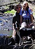
Here is a picture of the Wet Beaver Creek USGS gauge and the "weir" at its feet.
The picture was taken about 1:30p.m. on March 7. According to the USGS data, the flow you see is about 52 cubic feet per second. Wet Beaver Creek's overnight peak was EIGHT times higher than what shows in this picture. So you can expect a correspondingly higher level this afternoon here.
http://fromthedge.com/2003/graphics/wbc030703.jpg
Remember, this main USGS flow summary page gives a pretty good glimpse of how much water is flowing throughout the state:
http://az.waterdata.usgs.gov/nwis/current/?type=flow
J&S
The overnight low at 7300 feet at the Baker Butte SNOTEL was 30.9 degrees and yesterday's high up there was in the low 50's. That's a good indicator of what it's like all across the Rimlands snowpack. Sooo...when the overnight low temps fail to "tighten up" the meltage, successively higher daytime temperatures really take their toll on the snowpack.
Last night's peaks on Wet and Dry Beaver were nearly double the previous night's peaks.
The daytime "hiking flows" ought to be really "plumped up" during the next few days.
Of course, there's water EVERYWHERE so it doesn't matter where you go.
Here is a picture of the Wet Beaver Creek USGS gauge and the "weir" at its feet.
The picture was taken about 1:30p.m. on March 7. According to the USGS data, the flow you see is about 52 cubic feet per second. Wet Beaver Creek's overnight peak was EIGHT times higher than what shows in this picture. So you can expect a correspondingly higher level this afternoon here.
http://fromthedge.com/2003/graphics/wbc030703.jpg
Remember, this main USGS flow summary page gives a pretty good glimpse of how much water is flowing throughout the state:
http://az.waterdata.usgs.gov/nwis/current/?type=flow
J&S
contribute to this member driven resource
ie: RS > Save/Share after hikes