 Route Editor

Chevelon Creek/Canyon access fron Larson Ridge
Moderator: HAZ - Moderators
Linked Guides none
Linked Area, etc none
-
 Xiled1Guides: 0 | Official Routes: 0Triplogs Last: 2,169 d | RS: 0Water Reports 1Y: 0 | Last: 5,518 d
 - Joined: Feb 26 2009 10:59 am
- City, State: Mesa, AZ
Chevelon Creek/Canyon access fron Larson Ridge
Anyone know of a good way to access Chevelon Creek/Canyon from Larson Ridge Rd/FR237? Hoping to access further into the canyon, further down the road. Thanks.
contribute to this member driven resource
ie: RS > Save/Share after hikes 

-
 azbackpackrGuides: 34 | Official Routes: 30Triplogs Last: 43 d | RS: 0Water Reports 1Y: 8 | Last: 52 d
 - Joined: Jan 21 2006 6:46 am
- City, State: Eagar AZ
Re: Chevelon Creek/Canyon access fron Larson Ridge
Only place I've hiked it is between Chevelon Crossing upstream almost to the dam, where there was sort of a trail. I have heard that upstream of the dam it is seriously thick bushwhacking. I don't have a map in front of me to know if you are talking up or downstream of Chevelon Crossing.
There is a point of no return unremarked at the time in most lives. Graham Greene The Comedians
A clean house is a sign of a misspent life.
A clean house is a sign of a misspent life.
contribute to this member driven resource
ie: RS > Save/Share after hikes
-
 chumleyGuides: 94 | Official Routes: 239Triplogs Last: 12 d | RS: 73Water Reports 1Y: 92 | Last: 10 d
 - Joined: Sep 18 2002 8:59 am
- City, State: Tempe, AZ
Re: Chevelon Creek/Canyon access fron Larson Ridge
Liz it's 3-5 miles south (upstream) of the Telephone Ridge trail, well south of the Lake.
While I've never explored Larson Ridge myself, most of the canyon is accessible by some steep hiking. Rarely will you cliff-out, and when you do, it's usually a short distance to find a bypass around.
I know that you can get down Slim Jim Ridge north of 170G, but that gets you down to the popular Telephone Ridge area which you might as well access via the trail.
From 237, if I were exploring, I'd head for Larson Spring Tank and try entering the canyon by hiking due south from there. The elevation gradients look as manageable there as anywhere else along that ridge. Look for elk and bear trails. They usually know the best routes!
And if you succeed (or not), please post it here on HAZ. Others definitely are interested in the area and your shared knowledge would be helpful!
I'm not sure what my spirit animal is, but I'm confident it has rabies.
contribute to this member driven resource
ie: RS > Save/Share after hikes
-
Xiled1Guides: 0 | Official Routes: 0Triplogs Last: 2,169 d | RS: 0Water Reports 1Y: 0 | Last: 5,518 d
- Joined: Feb 26 2009 10:59 am
- City, State: Mesa, AZ
Re: Chevelon Creek/Canyon access fron Larson Ridge
Cool. We'll give it a shot and report back.
contribute to this member driven resource
ie: RS > Save/Share after hikes
-
Xiled1Guides: 0 | Official Routes: 0Triplogs Last: 2,169 d | RS: 0Water Reports 1Y: 0 | Last: 5,518 d
- Joined: Feb 26 2009 10:59 am
- City, State: Mesa, AZ
Re: Chevelon Creek/Canyon access fron Larson Ridge
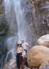
We drove down FR237 all the way to the overlook and I thought I saw a good way down. So we camped about a mile back that night and started in the morning. Turns out if you go north across the ridge, there is a pretty decent trail there with a few cairns. About a step above a game trail. Very steep and slippery, but doable for a hiker. Drops you down at the mouth of Long Tom Canyon. Bad news is that its only a mile or two from the Telephone trail. Or at least what I assume was it - long switchbacks that drop you into a meadow/burn area. So probably not worth a writeup. Still fun since I'd never been in this part of the canyon before.
contribute to this member driven resource
ie: RS > Save/Share after hikes