March 28-29th
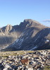
This hike will start at the Barnhardt trailhead and follow 6 miles to the junction at Barnhardt Saddle. We stay straight (west) passing Chilson Spring on the Mazatzal Divide trail before dropping into an unnamed canyon that will lead us, offtrail, to the North Fork Deadman Canyon.
Once we slowly navigate into the bottom of this twisting, towering, remarkable canyon we head upstream to the "grand show". The waterfalls here at the head of this canyon are almost 250 feet tall. We will camp at the base of these falls, on the bedrock there are some flat spots. Nobody that I know of has ever camped here before. I searched the web for any info on this area and Todd mentions rappelling the falls from above. It is my understanding from pouring over the maps that the falls can (and will!) be reached from the bottom. However, there will be hell to pay.
I dont even know if the loop hike i plan to make is even possible, as it looks as if there is a 40-80 feet waterfall preventing travel on the second day of the loop. Retracing our steps back the way we came in is highly likely.
The first day is straightforward and includes 8 miles on trail, and about 2 offtrail.
day two might be much more demanding (but we'll get an early start) wherein we should have up to 4 miles of unknown territory to navigate and then another 7 miles of trail to travel.
This is the Mazatzal range. Not for the timid. If you have not spent time here - this is not the time to make your first attempt! There is no other area I have hiked that is so demanding, requiring extreme navigation skills and hands-on canyoneering. Half the wilderness is burned. Even the trails shown on the maps are hard to follow. Please beware!
The HAZ wrecking crew should have no problem getting back home safely. Care to join me, you masochistic nuts?
Hike Arizona it is full of sharp, pointy, ankle-twisting, HAZmaster crushing ROCKS!!
Hike Arizona it is full of sharp, pointy, shin-stabbing, skin-shredding plants!
Hike Arizona it is full of striking, biting, stabbing, venomous wildlife!
Bahhh I'm doing Grand Gulch that weekend : / GL out there though......sounds like one rough adventure. Prolly need more experience in the mazats anywho.
I would love to see those falls, but I'm not doing your crazy person trip. Post pictures, I hope they're running well!
One day I'll take the slightly more sane route to the TOP of them.
"Arizona is the land of contrast... You can go from Minnesota to California in a matter of minutes, then have Mexican food that night." -Jack Dykinga
sarichter wrote:can't do an over-nighter unfortunately
time restraints or gear restraints?
both + responsibility restraints. my girlfriend won't be around to take care of my dog... my dog can't come because she's a husky and they don't work well off leash. the economy is crap so i don't want to spend the money on boarding her
besides, i will have to continue studying. luckily they rescheduled the catalina hike till April so i can join
oh cool. Chris always puts on a good show. Finger Rock trail looks nice. Im starting to do more hiking in the south half of AZ so coming up is the Safford-Morenci trail and then im going back to do Chiricahua Crest and I think the Rincon trip coming up w/ Alex is going to be good.
Im only doing W. Fork in between those times so most of my future hiking is going to be in the Sky Islands.
the question i think is not how many trees, but will we be able to hang as a tight group... i know there are trees and such in canyon bottom, as you can see in the pic there are a bunch scattered across the hillsides... sattellite photo shows a group of trees on the way in, about 200 yards from the falls.
anyway, to answer your question, YES< im going to hang.
i have updated the mileage as shown in the edited (original) post. This trip, according to the sattelite views, should be very easy as far as off trail goes. Looks like very minimal bushwhacking, and the creekbeds appear to be bedrock. Not much in the way of route finding, and an easy stroll, save for the initial decent into the canyon which drops about 200' over 1/2 mile. I cant believe there is no info on the web about seeing this place. Im sure someone has seen it, either native indians or miners. but not in the past 100 years?!
well we may just run into your group, Shawn. I had been planning this trip for about a year, so it was a great idea to be in the Mazzies but I just couldnt hike a trail that ive already done 2x, so i cancelled your trip in favor of this one. no hard feelings i hope!
im sure someone has made it down there but the written evidence of such a trip is elusive to say the least.
I talked to my friend, he has been there via Barnhart then to the top of the falls, then down around the side. He said he didn't recall it as a death march of any sort.
Shawn
The bear went over the mountain to see what he could see.
high 68
low 40
five degree give-or-take
looks like perfect weather
Shawn, from the top of the falls, after long consideration I have seen no way to go "down around the side" unless by that remark he means going in well below the falls, such as using the canyon we have in mind. I do find it interesting that so few have explored a place that is so close to say, Mesa. Then there's the Supes, which have been beat to death a thousand times over. (but the chances of minable gold in the mazzies compared to the supes is pro'lly 10,000 to one) ;)
 Route Editor