 Route Editor

Looking for beta on Spur Cross - Cave Creek Regional
Moderator: HAZ - Moderators
Linked Area, etc none
-
 SteveHallGuides: 0 | Official Routes: 0Triplogs Last: 2,984 d | RS: 0Water Reports 1Y: 0 | Last: never
 - Joined: Jan 05 2016 3:33 pm
- City, State: Cave Creek, AZ
Looking for beta on Spur Cross - Cave Creek Regional
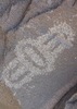
I did a search, but came up with nothing. I am looking for info on the hike from Spur Cross - Cave Creek Regional. What shape is the Maricopa trail in? Better/worse than RD 48 an the other side of Spur Cross? Whats the best rout to take once in Cave Creek Regional? Anything worth stopping at along the way? Any petroglyphs?
contribute to this member driven resource
ie: RS > Save/Share after hikes 

-
 rcorfmanGuides: 1 | Official Routes: 4Triplogs Last: 673 d | RS: 2Water Reports 1Y: 0 | Last: 1,124 d
 - Joined: Oct 17 2008 11:19 pm
- City, State: Phoenix, AZ
- Contact:
Re: Looking for beta on Spur Cross - Cave Creek Regional
I'm trying to remember when I was last out there. It's probably been five years or so. I know I rode a mountain bike out to the Spur Cross/Elephant Mt. trail junction and back, but I started out by Cavalry Rd in New River. I've been on all the other parts of the trail but again, it's been several years. At the time, the trails were fine. I think there's a fair bit of traffic from Cave Creek or Spear S Ranch to get to Apache Peak but I don't know what it would be like from where the Maricopa Trail breaks of from that and heads towards Elephant Mountain. It would be fun to get out there again.
Go find a LonelyCache
contribute to this member driven resource
ie: RS > Save/Share after hikes
-
 Sun_RayGuides: 0 | Official Routes: 0Triplogs Last: 117 d | RS: 137Water Reports 1Y: 0 | Last: 1,112 d
 - Joined: Sep 09 2004 11:53 am
- City, State: Scottsdale, AZ
- Contact:
Re: Looking for beta on Spur Cross - Cave Creek Regional
The signage has greatly improved over the last few years. Trails are now easy to follow in and out of Spur Cross. @dearth stiller had hiked this area and should be able to add imput.
Brian
Monday, Tuesday, Wednesday, Thursday, Friday, Saturday......there is no SOMEDAY!
Monday, Tuesday, Wednesday, Thursday, Friday, Saturday......there is no SOMEDAY!
contribute to this member driven resource
ie: RS > Save/Share after hikes
-
 Al_HikesAZGuides: 11 | Official Routes: 14Triplogs Last: 1,271 d | RS: 0Water Reports 1Y: 0 | Last: 3,411 d
 - Joined: May 16 2005 1:01 pm
- City, State: Scottsdale, AZ
- Contact:
Re: Looking for beta on Spur Cross - Cave Creek Regional
I've hiked from CCRP to Spur Cross and CCRP to Anthem. The Maricopa Trail is well marked and easy to follow. It really seems to be well designed for bikes and horses. There were some stretches along a dirt road were I wondered if I had left the trail, but then I picked up the signs. Coming from Spur Cross you will reach a T junction at about 24th Street(?). You'll know when you get here because you'll go through a little saddle and enter a residential area. Go left (easterly) to CCRP - go right (westerly) to stay on the Maricopa Trail over to 7th Street and the Spear S Ranch trailhead. This spot wasn't signed very well. If you blow it at this junction you will stay on the Maricopa Trail and end up at 7th St Spear S Ranch Trailhead. If you feel that you are spending too much time hiking in a residential area, you missed the junction. CCRP is actually a side excursion off the Maricopa Trail.
Anybody can make a hike harder. The real skill comes in making the hike easier.
life is like a roll of toilet paper. The closer it gets to the end, the faster it goes. Andy Rooney
life is like a roll of toilet paper. The closer it gets to the end, the faster it goes. Andy Rooney
contribute to this member driven resource
ie: RS > Save/Share after hikes