| | -
| |  |
|
2 |
-
-
-
-
| |  |
|
1 |
|
| | |
|
| Hiking | 16.60 Miles |
2,000 AEG |
| | Hiking | 16.60 Miles | 12 Hrs 30 Mns | | 1.33 mph |
| 2,000 ft AEG | | | | |
|
|
| |
| Linked |
|
none
[ show ]
| no linked trail guides |
| Partners |
|
none
[ show ]
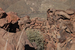
| no partners | | | We started our hike by the moonlight, which became a problem with the recent rains and wash hopping. While I was perched upon some rocks waiting for my jump over I heard the ever fatefull kersplunk, followed by a lot of choice words. Besides going in up to the knee's, all was well with my hiking compadre. I must say the squishing for the next hour or so was quite ammusing (only to me of cours). I believe we took Spur cross to 247 and then to 248 (skull mesa). Once on top we consulted our book of ruins and GPS and headed to the site. Well let me tell you that walking the top of the mesa was more difficult than getting there. From the trucks it was about 6 hours to the ruins, but well worth the effort, just incredible. After about an hour there taking pics, meandering, and a nice meal we headed back. Multiple petraglyphs on the way up and down. We ended up bushwacking a different route back and ended up on Cave creek trail #4 for the long journey back. We left the trucks by moonlight and got back by the moonlight, a long day but would do again in a heartbeat. |
| _____________________
| | |
|
|
|
|
|
| |
 Route Editor


