| | -
| 1 label | 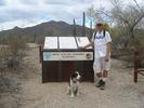 |
|
|
-
-
-
-
-
-
-
-
-
-
-
|
| | |
|
| Hiking | 6.00 Miles |
|
| | Hiking | 6.00 Miles | 3 Hrs | | 2.00 mph |
| | | |
| |
| Linked |
|
none
[ show ]
| no linked trail guides |
| Partners |
|
none
[ show ]
| no partners | | This trail ended up being our 2nd choice when we decided to visit the Sonoran Desert National Monument. Wanted to hike Table Top Mountain, but discovered in transit that pets are not allowed so that the desert bighorn sheep herd may be protected! Oh well, had Buster our springer spaniel with us and needed a quick alternative - so Margie's Cove Trail became the destination!
From Maricopa Road (Hwy 238), exited on the Butterfield Stage Route. Interesting historic sites along the way including some rock art, the Juan Bautista de Anza National Historic Trail, and the Mormon Camp Trail.
After about 30 minutes following the 4WD trail, we branched east to the Margie's Cove Trailhead. Maps and a trail log are available at the trailhead.
The trail itself is relatively easy, following the wash along the valley. Only a slight elevation gain of about 500 ft is encountered along the 9 mile length. Trail is an excellent example of a saguaro forest within an hour's drive of the city. |
| _____________________
| | |
|
|
|
|
|
| |
 Route Editor


