| | -
-
-
-
-
-
-
-
-
-
| |  |
|
2 |
-
-
-
-
-
| |  |
|
3 |
|
| | |
|
| Hiking | 3.90 Miles |
2,489 AEG |
| | Hiking | 3.90 Miles | | | |
| 2,489 ft AEG | | | | |
|
|
| |
| Linked |
|
none
[ show ]
| no linked trail guides |
| Partners |
|
none
[ show ]
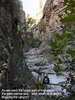
| no partners | | It is only about 2 miles into the ruins from Cherry Creek Road, so how tough could that be? We usually do 6 to 8 miles on our weekly hikes. Well, the elevation gain in those two miles is about 2000 to 2500 ft, meaning an average grade of 19 to 24%. But that is not the worst of it. The terrain is rugged. And for the last quarter mile you leave the bottom of the canyon and literally crawl up the side of the canyon to the ruins, grabbing for bushes along the trail to help pull yourself up. This part is steep and loose, so you take three steps up and slide back two. I ended up doing the last 200 yards or so on all fours. Suffice it to say, "It's not the mileage; it's the terrain and elevation gain."
This turned out to be one of the most difficult, if not THE most difficult, 2 miles I have ever walked. Round trip (4 miles) took us 6 hours and 45 minutes, with only about 30 minutes spent at the ruins themselves. We had lots of rest stops and photo stops - and I needed every one of them. Of course, my two hiking partners, the youngest being 25, had up to 46 years on me, so I'm at a considerable disadvantage here - give me a break ;>). But, I made it.
We want to thank Randal for the use of his posted GPS route, it helped immensely until I lost signal in the canyon about the time we headed up the side to the ruins. But by that time we didn't need it. We also want to thank whomever placed the ropes at the big boulder and at the cascading falls a short piece upstream from the boulder. We may have turned back without these. Don't know when they were placed, but the ropes are still in good condition.
But the trip was worth it. The cliff dwellings were magnificent, especially considering that they are protected only by federal law and not by any fences or constant surveillance as they might have if they were a part of a national monument or park. These have been dated by tree ring analysis of the posts and beams of the structure, to be about 700 years old. There are multiple rooms and (were) multiple floors. They are perched on the side of a canyon wall so close to the edge that you can't get around them. You have to go through them to get to the other end.
I can't image anyone building these where they are. And I can't image raising kids in such a place. Maybe they left because the loss of life was too much. Or maybe they just used these as a resort or for romantic getaways, who is to say ;>) . The views are splendid.
This is the ideal time to go. Didn't see any snakes. Temperatures were in the high 50s, low 60s. Water flow is low, making scrambling the falls much easier and safer. Cherry Creek Road is good except for the 2 miles or so beyond the Elliston (sp?) ranch. Even there you could get your (not mine though!) normal passenger car over it if you were very careful. No low riders or sports cars, though. High clearance is great. 4W not necessary in dry weather.
I posted pictures. More can be found at http://evansstowage.com/Hikes/DevilsChasmRuins
Oh, I almost forgot to mention. GPSJoe (if I remember right) got a ticket or warning on 188 on his trip back from some hike in this vicinity. So I was very careful to stay near the 55 posted limit. Well a DPS officer stopped me just short of the junction with US60. At the time, I was slowing down to the 35 limit I saw on a sign. I had been going about 59 or 60 before that, which is what he "warned" me about. Turns out that Globe has annexed the land that extends 7 to 9 miles up 188 and has posted it at 45 since it is "in the city." I had missed the sign (he said it was about where the little market is along 188. But he left me off with a warning, since I looked like a tired hiker ;>) . I guess they didn't annex along Cherry Creek Road, since you can't drive over 30 anyway. Got to keep the city coffers full!
(note added later) I just now noticed the posts with the sad news about GPSJoe. I didn't know him personally, but communicated with him through HAZ several times. He was always very helpful. We also made use of several of his GPS tracks and his hike writeups. My thoughts and hopes are with him. |
|
Autumn Foliage Observation Moderate
|
|
|
Wildflowers Observation Isolated
|
|
| _____________________
| To plunder, to slaughter, to steal, these things they misname empire; and where they make a wilderness, they call it peace. -- Publius Cornelius Tacitus (56 AD – 117 AD) |
| | |
|
|
|
|
|
| |
 Route Editor


