| | -
-
-
-
-
-
-
-
-
-
| 1 label | 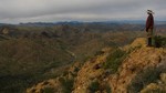 |
|
|
-
-
-
-
| 1 label | 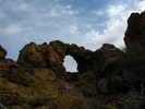 |
|
1 |
-
|
| | |
|
| Backpack | 11.50 Miles |
2,500 AEG |
| | Backpack | 11.50 Miles | 2 Days | | |
| 2,500 ft AEG | | | | |
|
|
| |
| Partners |
|
[ show ]
| partners | | This was a 4-day backpack but I'm splitting my Triplog into two so I can keep track of my 2011 mileage.
December 30 - It was raining like crazy when we left Tucson on Thursday morning. Our party was supposed to be 10 people and we were down to 5 due to the forecast for weather conditions. I was now the SAHC guide for the trip since my co-guide had dropped out. We started at the first First Water TH, thankfully it wasn't raining. We took the Dutchman trail up and over Parker's Pass. There was water running every where which meant that we had some stream crossings to contend with. The views were very dramatic along the trail all day because of the storm clouds. It was cold and windy which made finding a perfect spot for a lunch break -but we did find one just before Parker's Pass. We had a great view of Weaver's Needle, which had a bit of snow dusting. After lunch we had one of our more challenging creek crossings, which was were O'Grady and West Boulder Canyons merge after Parker's Pass. One in our party nearly fell in but ended up just a little wet. Thankfully, she was an experienced wet weather backpacker and wasn't wearing any cotton.
When we got to the Bull Pass Trail junction we could see that some sort of weather was heading our way. Just in case it was rain we put on our pack covers. We ran into three guys who were headed back to their cars. They said that they didn't advise crossing La Barge because the water was thigh high in places. Right after that we crossed East Boulder Creek which required a little bit navigation around the bushes and the water.
On the trek up to Bull Pass, it started to snow. It was peaceful and beautiful. There is nothing like seeing snow on saguaros, agave, and hedgehog cactus to put a smile on your face. After the pass we had our last stream crossing which was Needle Creek. This one seemed like it might be the highest we had to cross. Overall, we faired well when it came to crossing the creeks.
The the Cavalry and Dutchman junction we had to choose which way we wanted to go to camp. We chose to go on the Cavalry trail for just a quarter of a mile to see what we could find in the way of a campsite for 3 tents out of harms way in case it rained more.
From camp we could see a waterfall coming off from Bluff Spring Mountain. I decided that in the morning I wanted to check out the waterfall. We had originally planned to do a loop day hike, but with all the water and the cold we decided we wanted to try to keep our feet wet.
On Friday morning there was frost everywhere. The temperature was into the low 20s. No one wanted to get out of their tents too early! The weather forecast had lied to us when it said sunny and cold instead we were in for a cloudy day - but no rain, so we were happy! After we were ready we embarked on our adventure to see the waterfall up close. We ended up hiking up to a point on the Northwest end of Bluff Spring Mountain that wasn't actually connected to the mountain. However, we had the best views of Needle and La Barge Creeks. We also found a small arch. It was definitely worth it! We hung out for a while and ate our lunch. From there we went down a bit and contoured over to where we had seen another notch in the rocks that we had seen (earlier the sun had peaked directly through it and we were laughing about how it was a sign). From there we were able to access Bluff Spring Mountain. One of the first things we saw was a bucket of rocks! From there we made it to the end of the drainage where the waterfall was. We were able to get a good view of the top of the waterfall but we didn't chance going all the way down to that point. Above the waterfall was a nice area of rocks and pools where we had a break.
On our way back to camp we run into an area that looked like at one point some Native Americans had lived. There were some pottery shards and what looked like an indention for a pit house. I also found what looked like a guard rail not far away - I'm not exactly sure why that was there.
My goal for December was to hike 100 miles. At this point I was shy about a mile, so we hiked a bit further up Dutchman to see what La Barge looked like up there. The creek was still pretty high. There were several good campsites in that direction. However, we decided that our camp site was warmer!
That night, I learned a valuable lesson. Don't "incubate" your hydrating food in your down jacket and move around. I suddenly felt something very hot on my stomach. I had cheese sauce inside my jacket! Luckily, I had brought two down jackets so I was able to dry out the one and still stay warm. Dinner was still good  |
|
Autumn Foliage Observation Isolated
|
|
|
Wildflowers Observation Isolated
|
|
| _____________________
| | |
|
|
|
|
|
| |
 Route Editor


