| | -
-
-
-
-
-
-
-
-
-
| |  |
|
1 |
-
-
-
-
-
|
| | |
|
| Hiking | 7.50 Miles |
2,595 AEG |
| | Hiking | 7.50 Miles | 5 Hrs 31 Mns | | 1.36 mph |
| 2,595 ft AEG | | | | |
|
|
| |
| Linked |
|
none
[ show ]
| no linked trail guides |
| Partners |
|
[ show ]
| partners | | Having made a failed attempt at this hike last week, we came back with a vengeance to git 'er dun come hell or high water. First we made sure to have accurate information, we left home earlier, made much better time on Cherry Creek Road, wasted little time fording the wet wash by Devil's Chasm (steep approach angle had front bumper completely under water) and kept a good pace on the roughest part of the drive to the trail head. Whew! 2 hours and 25 minutes from doorstep to trail head. (Only to find at the end of the hike the true trail head is NOT where the old mine road cross FR203. More inaccurate info, I guess)
On to the hike...
It promised to be a great day for a great hike, with the temperature starting in the low 50's and not a cloud in the sky! No walking any flat ground to loosen up this hike, it's a solid 1000' foot climb in the first mile,  and most of that on loose, sharp rock. and most of that on loose, sharp rock. ](https://hikearizona.com/dex2/images/smilies/eusa_wall.gif "Brick wall")
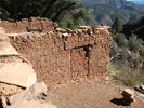
Not wanting to repeat our lost efforts the last two times, we didn't bother to stop for a moment until we had passed the 5000' elevation mark. With a 2 minute break we were back on the trail, or at least most of the time I think we were on the trail. Whenever we had a clear view across the canyon we took photos of the ruins, whetting our appetite with each shot.
The farther along the trail we went, the more often we'd come to some areas of pretty good exposure, forcing us to keep our eyes on the trail and our mind focused on where we stepped. The Manzanita forests some have complained about didn't bother us at all, but the tons of sharp-edged leaves of the holly got to be a pain. At least they didn't tear through clothing and skin so we didn't complain too much.
The first place where the brush seemed to clear out was approaching the old uranium mine and the only ruin on the south canyon wall. We spent but a few moments at the mine, taking one shot of the entrance and one zoomed shot of luminous deposits about 20 feet into the mine. Unfortunately that photo didn't turn out... must have been the radiation, don'cha think? 
Not wanting to end up  we followed good advice we followed good advice  and stayed away. and stayed away.
Leaving the mine we perused the first ruins we came to but being so small and with more to come we pressed on. Back into dense brush and a steeply angled trail we were working up a sweat even with an intermittent waft of a cool breeze. But not far and we came to the waterfall at the head of the canyon. After a few photos we passed carefully behind it so as not to slip and fall. Knowing we were getting closer to the main ruins, even though into dense brush again, we picked up our pace, eager to explore.
Rather than document each and every item of note we came across, I'll leave it to the photos I posted on my web site, as they pretty much tell the story.
The only editorializing I'll do is to make note of the thoughtless "artists" who desecrated the ruins with their graffiti. As the photos attest, there is no generation that doesn't have it's share of folk out to put their name on and/or erase history. The minuscule amount of artifacts left provides further evidence of desecration. Shame on those folks!
Ok, ok, I'll step off the soapbox now.
I took a number of videos but as usual it will probably be a while before I get a chance to edit and post them. When I do I'll come back and add the links here. It will have to suffice for now to post the still photos.
Hike photos are here:
http://www.changephoenix.com/10/2010-11-01PuebloCanyonRuins.html |
| _____________________
| | |
|
|
|
|
|
| |
 Route Editor


