| |
| Super Pipeline 4 Springs Crest Baldy, AZ | | -
-
-
| 1 label | 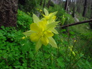 |
|
|
-
| 1 label | 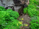 |
|
|
-
| 1 label | 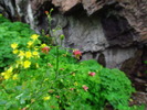 |
|
|
-
| 1 label | 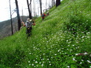 |
|
|
-
| 1 label | 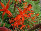 |
|
|
-
| 2 labels | 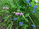 |
|
|
-
| 1 label | 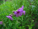 |
|
|
-
| 1 label | 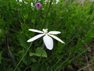 |
|
|
-
| 1 label | 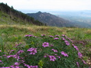 |
|
1 |
-
-
| 1 label | 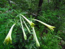 |
|
|
-
-
|
| | Super Pipeline 4 Springs Crest Baldy, AZ | | | |
|
|
Super Pipeline 4 Springs Crest Baldy, AZ
| | |
|
| Hiking | 13.50 Miles |
5,400 AEG |
| | Hiking | 13.50 Miles | 7 Hrs 25 Mns | | 2.35 mph |
| 5,400 ft AEG | 1 Hour 41 Mns Break | | | |
|
|
| |
| Partners |
|
[ show ]
| partners | | This is one of my favorite hikes in the Santa Ritas. In fact it's turning into an annual event. You need about a year to recover 
There were a total of 7 of us this year. Funny enough, no one returned from last year's trip. We even had two new people who had recently joined the group - no one has had a chance to warn them yet! It was a awesome group - we pretty much stay together the whole time.
We took the Super trail for a short distance and then jumped onto the pipeline trail. We got to Sylvester Spring pretty quickly, in fact I wasn't even expecting it and it jumped out at me. From there we began the long slog up an old mining road to Kent Spring. At Kent Spring we got on the unsigned Four Springs Trail. As we climbed, contoured, and switched back we kept seeing flowers. At one point, Deb pointed out a ridge line that we could take to go to Roger's Rock. We also saw good views of Santa Rita Peak, Mt Hopkins, and Mt. Wrightson.
We took a welcomed break at Shovel Saddle. You could see the burn area the stretches down from Pine Saddle. There is a lot of new growth in the area. We continued along the trail and I was surprised to find that some trail maintenance had been done right after the saddle (thank you!). Elephant Head popped into view and was a treat to see.
Finally, we reached the spot on the trail where one could depart to visit McCleary. We decided to not do any optional peaks today. From this point up to the Crest trail we were treated to the most spectacular color display. There were Columbines galore, Richardson Geranium a plenty, and bright Paintbrush just to name a few! The Columbines had monopolized the area around Armour Spring. It was delightful! At this point, I couldn't take it any more and I got out the camera.
We got on the Crest trail and were treated to views to the South. Everything was green. The rains really have been good to Southern Arizona!
At Baldy Saddle we ran into the first people outside of our party. We had been spoiled up until this point. Surprisingly, there wasn't really that many people out hiking the Baldy Trail.
At the top, we enjoyed our lunch as well as some treats. Then we zoomed down the Old Baldy Trail with a brief stop at Josephine's Saddle.
Awesome views of the surrounding area and the amazing flower display makes this a great late August hike! |
|
Wildflowers Observation Extreme
|
|
| _____________________
| | |
|
|
|
|
|
| |
 Route Editor


