DESTINATION Fortuna Peak - Gila Mtns 1 Photoset
2011-08-21 | | -
-
-
-
-
-
-
| 1 label | 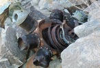 |
|
|
-
| 1 label |  |
|
3 |
-
-
-
-
-
-
-
| 1 label |  |
|
2 |
|
| | |
|
| Hiking | 1.71 Miles |
1,730 AEG |
| | Hiking | 1.71 Miles | 4 Hrs | | 0.43 mph |
| 1,730 ft AEG | | | | |
|
|
| |
| Linked |
|
none
[ show ]
| no linked trail guides |
| Partners |
|
none
[ show ]
| no partners | | | A short hike in the foot hills east of Yuma. Had a free day while on a business trip and needed to get out and stretch a bit. Choose this hike for a couple of reasons. It is a TerraCaching destination (http://www.terracachin... No longer available, still a good source for other quality caches so I'll leave the main link active), B17 crash site, and not too long considering the season. Had a great hike, would recommend to anyone. |
| _____________________
| | |
|
|
|
|
|
| |
 Route Editor


