| | -
-
-
-
-
-
-
-
-
-
| |  |
|
2 |
-
-
-
-
-
|
| | |
|
| Hiking | 1.90 Miles |
1,306 AEG |
| | Hiking | 1.90 Miles | 2 Hrs 57 Mns | | 1.41 mph |
| 1,306 ft AEG | 1 Hour 36 Mns Break | 28 LBS Pack | | |
|
|
| |
| Linked |
|
none
[ show ]
| no linked trail guides |
| Partners |
|
none
[ show ]
| no partners | | Ok, here it is... Picketpost East by the numbers:
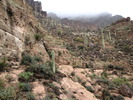
1. Drive through mud, over cattle guard, up rocky hill, down steep rough and rocky hill, up another, over a high stepped cattle guard, down a bunch of boulder steps, up, down, up, down and you're at the TH. Or something like that...
2. I can't even see the base of the mountain and thus have no idea what route to start on, so I kept on driving for a few hours checking out every side road over a 3 mile radius.
3. Ok, a little clearing of the fog and I'm ready to start hiking. A hundred yards of warm-up then it's time to burn the calories... I'm following game trails as much as possible but no being the size of game I have to abandon each one much too soon.
4. Climb through a cholla forest at the same time as carefully placing each step so as not to slide back every other step on the loose gravel. Climb up boulders using every piece of brush available to gain purchase.
6. Traverse along a narrow ledge until it's time to do the real steep climbing. Not so much straight up since there are plenty of ledges, but the quick altitude gain is the killer.
7. Heavy fog has descended again and all I can do is keep checking my GPS to keep me going the overall direction as I have to continously pick out the best route for the next 20-50'. I see a ridge, hoping it brings me to the plateau... I get there and there's another... one more time and I know I'm within 300' of elevation from the white horeshoe cross I know is up there and it's hopeless, I have no idea where to find the path through the boulders.
8. Head back down before the heavy gray clouds roll in. In more of a hurry now I choose a different route that would probably cut a good 15-20 minutes off the climb. Yup, it's always easier to pick the fast route on the way down.
9. The final part of the route takes me through cholla (a different forest on the return trip), prickly pear, ocotillo and palo verde before I get back to the car.
10. I'm totally soaked through 4 upper layers, I have dirt all over me from the body slides and weirdly enough, my socks are the cleanest item although thoroughly wet as well since I was wearing my Teva's.
That's it for the hike... although aborted I feel it was successful because I know it can be done... and I'll be doing it soon, like in a day or two.
The drive after the hike again took me past Ajax Mine where I took some photos of the mine itself (instead of the mill as before) and the few tailings.
Video of a rough part of my climb is coming soon. |
| _____________________
| | |
|
|
|
|
|
| |
 Route Editor


