| | -
-
-
-
-
-
-
-
-
| 2 labels | 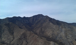 |
|
|
-
-
| 1 label |  |
|
|
|
| | |
|
| Hiking | 4.80 Miles |
1,888 AEG |
| | Hiking | 4.80 Miles | 4 Hrs 4 Mns | | 1.61 mph |
| 1,888 ft AEG | 1 Hour 5 Mns Break | 16 LBS Pack | | |
|
|
| |
| Linked |
|
none
[ show ]
| no linked trail guides |
| Partners |
|
none
[ show ]
| no partners | | I set out on this hike with one goal in mind - Bag Bob Thompson Peak - or find out why it wasn't possible. My goal of bagging at least 5 peaks (well known or otherwise) in the Huachucas this season included a long held wonderment around BTP: why is it not listed on this or other relevant sites...perhaps it is just too easy and not worth the time...[?] Wrong!
The forest service road at the trail-head has a stout new gate and signage since the fires of June 2011. The topography is charred in all directions, giving an apocalyptic quality to the steep ascent - where sustained 30-40% grades are the norm - you'll be putting the brakes on during the descent. I turned-in an 8 minute mile coming down without intending to. If you are looking to boost your AEG average this is a hike that can help. The saddle and ridge are well worth the effort, and the views of Miller Peak are encouraging along the way.
The ridge opens up to stunning Sonoran views and is shadowed by Montezuma Peak (WSW) the parent peak to BTP. The trail turns sharp to the east and becomes less obvious as it works through the spine of the ridge-back over exposed scramble in three main areas - could be daunting on windy days - as this interplays with an unmarked trail and is now a true outback romp as bouldering gives way to the prominent fully exposed outcrop standing between you and the peak. Having reviewed this in great detail (via Google Earth in 3D) I was concerned that the trail as is listed on regional maps, might not be passable, and in fact this is the case. The goat path on the steep ridge working its way around the north face ends abruptly as it has been eroded away into the reintrant below.  The trail picks-up across this chasm about 30 - 40' ahead... The only thing is the overt 500-600' drop - this is the end of my tether for solo hiking. Not another step! A slow 180 turn and reverse course - as a nice break on that stone patio back a ways will do just fine... Bob Thompson Peak is baggable in a small group and with a bit of climbing experience / gear to work around the section outlined. The trail picks-up across this chasm about 30 - 40' ahead... The only thing is the overt 500-600' drop - this is the end of my tether for solo hiking. Not another step! A slow 180 turn and reverse course - as a nice break on that stone patio back a ways will do just fine... Bob Thompson Peak is baggable in a small group and with a bit of climbing experience / gear to work around the section outlined.
I rolled my ankle forward twice while descending the bouldering portion of the ridge...greatly increasing break-time during this outing. The overall avg. grade for this hike is 57.4%. GPS Route Available. |
| _____________________
| | |
|
|
|
|
|
| |
 Route Editor


