DESTINATION Generic 59 Photosets
| |
| Eagle Eye Arch & Peak, AZ | | -
| 1 label | 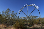 |
|
|
-
-
-
| |  |
|
1 |
-
| 2 labels | 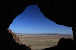 |
|
|
-
| 2 labels | 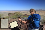 |
|
|
-
| 1 label | 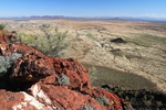 |
|
|
-
-
-
| |  |
|
1 |
-
| |  |
|
1 |
-
|
| | Eagle Eye Arch & Peak, AZ | | | |
|
|
Eagle Eye Arch & Peak, AZ
| | |
|
| Hiking | 2.85 Miles |
811 AEG |
| | Hiking | 2.85 Miles | 3 Hrs 27 Mns | | 1.25 mph |
| 811 ft AEG | 1 Hour 10 Mns Break | 12 LBS Pack | | |
|
|
| |
| Partners |
|
[ show ]
| partners | | The old west continues to intrigue. Pam said Preston was too big of a wuss to man up and conquer the peak so I had to step in.[1] This one starts wherever you please and Eagle Eye Cemetery works well. Shamefully trashed on the perimeter it boasts an intriguing twist. That being the attention to detail and creativeness in signage and fencing.
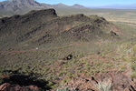
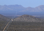
Eagle Eye "mountains" are the northeastern terminus of the Harquahala range. Everyone knows the song hark wha hala angles sing, glory to the bla bla bla... naturally I couldn't resist the adventure! It's difficult to explain. There is just something about the views from this range that intrigue. The contrast between peaks and flat expanse has a cinematic quality.
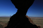
Upon reaching the arch the wind was borderline dangerous. Pam mentioned a route over the arch. I checked it out. It's almost rlrjamy (the artist currently riding the little bo peep moniker) type stuff. Getting up looks doable, getting down in gale force winds... not this cowboy.
Thus began the hunt for Red October. Riddle me this... Eagle Eye "Mountain" is black whereas Eagle Eye "Peak" is red. We searched and searched then found a route up directly to the peak. Difficult this was not. Rather enjoyable beyond anticipation.
1) exaggeration and falsification added for shock value |
|
Wildflowers Observation Isolated
Itty bitty and sparse for the most part. Down in the valley poppies dabbled on occasion. |
|
| _____________________
| | |
|
|
|
|
|
| |
 Route Editor


