DESTINATION Generic 104 Photosets
| |
| Pyramid-National-Ruins Loop, AZ | | -
| 1 label |  |
|
1 |
-
-
| 1 label |  |
|
|
-
| 1 label |  |
|
|
-
| 1 label | 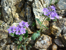 |
|
|
-
| 1 label | 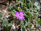 |
|
1 |
-
| 1 label |  |
|
|
-
| 1 label |  |
|
1 |
-
| 1 label | 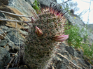 |
|
|
-
| 1 label | 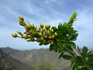 |
|
|
-
| 1 label | 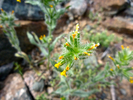 |
|
|
-
| 1 label |  |
|
|
-
| 1 label | 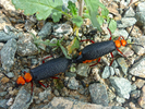 |
|
1 |
|
| | Pyramid-National-Ruins Loop, AZ | | | |
|
|
Pyramid-National-Ruins Loop, AZ
| | |
|
| Hiking | 7.75 Miles |
1,946 AEG |
| | Hiking | 7.75 Miles | 2 Hrs 37 Mns | | 2.96 mph |
| 1,946 ft AEG | | | | |
|
|
| |
| Partners |
|
none
[ show ]
| no partners | | Decided to test my post-illness breathing and stamina, and did ok. I like the Pyramid Trail for it's flat warm-up followed by moderate gain on a reasonably graded switchback trail. The next 4 miles are pleasant rolling ridgeline with just a gentle overall climb, followed by the roller-coaster drop that is the Ruins Trail. Returning on what was a flat warm-up at the beginning is longer and more boring than I would prefer.
The hill caught my breath and muscles a bit, but the rest of this hike was cake. I might extend the loop to return on Bursera next time, increasing mileage and AEG.
Wildflowers were sparse and small, though I managed to spot a fair number of different kinds. The north-facing slopes had the most coverage.
I know the Poppy. I hope somebody will identify the rest for me!  |
|
Wildflowers Observation Light
|
|
| _____________________
| I'm not sure what my spirit animal is, but I'm confident it has rabies. |
| | |
|
|
|
|
|
| |
 Route Editor


