| |
| Sugarloaf (Spur Cross), AZ | | -
-
-
-
-
-
| 1 label | 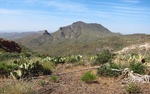 |
|
2 |
-
-
| 1 label | 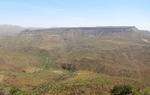 |
|
2 |
-
| |  |
|
2 |
-
| 1 label | 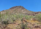 |
|
|
|
| | Sugarloaf (Spur Cross), AZ | | | |
|
|
Sugarloaf (Spur Cross), AZ
| | |
|
| Hiking | 8.30 Miles |
2,400 AEG |
| | Hiking | 8.30 Miles | 6 Hrs 25 Mns | | 1.29 mph |
| 2,400 ft AEG | | | | |
|
|
| |
| Partners |
|
none
[ show ]
| no partners | | I didn't have a firm plan as I drove toward Spur Cross but by the time I got there I thought maybe I'd head toward the top of Elephant Mountain.
I stopped at a couple ruin sites along the way and decided to take the "2nd left" (i.e. not the first one marked "EM trail"). I was enjoying the walk (except for the vast clouds of gnats) but noticed after a while I was heading away from Elephant Mountain. I studied the GPS map for a couple minutes and realized I had branched off the main trail and was heading up a creek toward the Black Mesa-Sugarloaf saddle. It was a decent trail, plenty of cairns, so I just kept going.
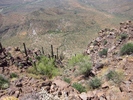
The trail led to a nice spring (Peterson Spring?) and after that I bushwacked up to the saddle. The saddle is a nice spot but it was a slow, ugly grind up the backside of Sugarloaf. There were two good cairns on top but I didn't find a register. I continued east to the far edge of Sugarloaf - descent here looked steep and unappealing - but retracing my way up was too. So I did a "5 wheel skid" down the SE side, starting in a gully but then exiting right. Slow and ugly.
I was happy to intersect Tr#252 and took that loop back to the car.
Can't recommend this one but I was glad to get outside and I won't have to wonder what the top of Sugarloaf is like anymore. |
| _____________________
| | |
|
|
|
|
|
| |
 Route Editor


