| | -
| 1 label |  |
|
|
-
-
-
-
| 1 label | 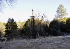 |
|
|
-
-
-
-
-
-
-
-
-
-
|
| | |
|
| Hiking | 8.50 Miles |
1,750 AEG |
| | Hiking | 8.50 Miles | 3 Hrs 45 Mns | | 2.43 mph |
| 1,750 ft AEG | 15 Mns Break | 10 LBS Pack | | |
|
|
| |
| Partners |
|
none
[ show ]
| no partners | | I had to finish what I started.....
I first started at the GPS coordinates of the Medlar TH. There is no real parking, or Trailhead markings. So I decided to start in a location to where I felt safer parking.
I hiked the Medlar Springs Trail to the end, then backtracked to the Ash Creek TrailHead. I then hiked the Ash Creek trail to the point of where I turned around back in October. ( http://hikearizona.com/gps=25181 ) Trail finding can be a pain in some areas. |
| _____________________
| | |
|
|
|
|
|
| |
 Route Editor


