| |
| GATES BM and County Hi Point, WI | | -
-
-
-
-
-
-
-
-
-
-
-
-
-
| 1 label | 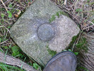 |
|
|
-
| 1 label | 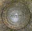 |
|
|
|
| | GATES BM and County Hi Point, WI | | | |
|
|
GATES BM and County Hi Point, WI
| | |
|
| Hiking | 1.05 Miles |
80 AEG |
| | Hiking | 1.05 Miles | 1 Hour 58 Mns | | 2.03 mph |
| 80 ft AEG | 1 Hour 27 Mns Break | | | |
|
|
| |
| Linked |
|
none
[ show ]
| no linked trail guides |
| Partners |
|
none
[ show ]
| no partners | | This was a short hike to a triangulation station and coincidentally, to the highest point in the county.
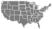
Most of the elevation in Walworth County, Wi. is between 800 and 1,000 ft. The high point is about 1,140 ft, amongst very gradual rolling hills and meadows, just north of Williams Bay, Wi. which is a city located on Lake Geneva.
All these hills, meadows, and lakes were formed by receding glaciers a zillion years ago.
In this one small area, there are actually many little knolls that are considered the ‘county’s highest-point(s)’, depending on the source. GATES Triangulation Station is located on one of them.
In 1935, GATES BM was monumented on a farm, owned by Henry Gates. (ergo the BM name). The land is no longer a farm.
Part of the original farm is now a golf course with home sites. Also, in 1950 a U.S Air Force ‘Early Warning Radar Station’ was established on part of the Gates farm land. The Air Force purposely chose one of the farm’s high-points for their radar tracking mission during the 1950s Cold War era. The Air Force decommissioned the radar site in 1960 (along with most others) when ICBMs took over the Cold War threat. No need to track and ID every plane in the country’s interior, looking for Russian bombers, when supersonic missiles were developed. The Air Force radar site is now an industrial park.
Ironically, the area around the actual benchmark is still forest, and uncultivated rolling fields. This time of year, those fields are full of very tall grasses and other vegetation, with some of the vegetation as tall as me. Hiking in that tall stuff was like hiking in the blind. Not knowing if I would step in a hole or on uneven ground, my every step in the tall grasses was similar to a side-swiping soccer ball motion, to first flatten the grass so I could see the ground prior to stepping forward. For such a short hike, this tall vegetation section was a pain.
By the way, I had checked Google Earth prior to the hike, and the imagery was from early April, when these fields had no vegetation at all. My Bad - for doing this hike in mid-August when all plant life was in full vigor.
Finding this benchmark was quite a challenge.
With all that tall grass, even the witness post was totally obscured. I initially gave up on the BM and looked for the two reference marks, supposedly near fence lines (in 1935). I found the fence lines, then found both reference marks in and around alot of very thick brush, and the dilapidated fences. I then did some course measuring from both reference marks and where the two courses crossed, I found the BM’s witness post, but no disk. I did some digging and found the actual BM disk buried beneath the tall grass, 2 inches below the dirt.
I found the azimuth mark also, which is usually the most difficult disk to locate.
Well, GATES Azimuth Mark was easy to find, as It’s beside (and in the right-of-way of) a road, 1/2 mile away. The right-of-way had freshly cut grass and the azimuth mark is in a cement block, projecting 6 inches above the cut grass.
Heck, I could even see the cement block on Google Earth before I did the hike. 
All in all it was a good little hike with four, 79 year old disks located.
Also, I can now brag that I ‘climbed’ to the highest point in Walworth county. Not many people can brag about that achievement.  |
| _____________________
Not All Those Who Wander Are Lost
J.R.R.TOLKIEN |
| | |
|
|
|
|
|
| |
 Route Editor