| | -
-
-
-
-
-
-
-
-
| 1 label | 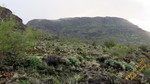 |
|
|
-
-
-
-
| 1 label | 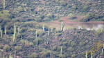 |
|
|
-
-
|
| | |
|
| Hiking | 7.50 Miles |
2,359 AEG |
| | Hiking | 7.50 Miles | 5 Hrs 50 Mns | | 1.37 mph |
| 2,359 ft AEG | 21 Mns Break | 25 LBS Pack | | |
|
|
| |
| Partners |
|
[ show ]
| partners | | On the hike with Ray to the AZNG mascot just over 2 weeks ago El Recortado was hard to miss, which brought to mind I hadn't been out that way since doing the "El Rec West/East" double in June 2014.
So... what better time than now to drag Ray out there as well.
The plan was to drive out to Brownie Tank in the dark and hit the trail 30 minutes before sunrise. Ok, so we were 30 minutes behind schedule. Ray might claim some responsibility, but extra drive time was the bigger issue. The FS had closed off a few roads in The Rolls since I had been out there last so we were unable to take the shortest straightest route. Plus, it was dark.
(We'd only realize just how bad the road was when driving back out in the light of day.)
The forecast called for cloudy til mid-morning then partly cloudy so when we were greeted by such a heavy overcast, I didn't expect that to change so we just got on with it. It would threaten rain pretty much throughout the hike but we were lucky to avoid it.
However, for the record... I'll take 105 and 12% humidity over 55 and 80-95% humidity any day. It might as well have rained as I was soaked with sweat within 15-20 minutes of beginning the hike.
We stuck close to the route of my hike back in June 2014. (with the exception of the first mile)
- Started from Brownie Tank, follow the wash SE for .7 mile
- Turn east and go .2 mile over to a saddle then drop 120' into Cottonwood Creek
- Continue .25 mile south in the wash
- Turn and begin climbing southeast, gaining ~200' over the next .25 mile
- Traverse the slope east .25 mile
- Climb 200' up a drainage to the north
- Continue due east a half mile with little elevation gain, the main hazard being cholla
- Climbing east up the longest/steepest slope of the day, gaining 400 feet in .25 mi
- Passed the 2857 'summit' then began an 'around the edge of the mesa' counter-clockwise arc to the true summit of El Recortado 'East'. (While unmarked on the map, the elevation is 2900')
- From there we continued east a half-mile to the slope of decision... 
Almost three hours to reach here, likely another 2-3 hours to drop down 600 feet, climb up to 3068, back down and up to this point, plus another 3 to get back to Brownie Tank...
Hmmm... it's getting cooler, which I'm definitely feeling since I'm soaked through and through with sweat and the sky isn't looking any better, I think we'll call it a day and have extra time for some wandering on the return.
(Unlike my last trip out here, discretion would be the word of choice today.)
We decided to try a different route to drop back into Cottonwood Creek and split up...
I continued down a wash until reaching a ~75' pour-off ](https://hikearizona.com/dex2/images/smilies/eusa_wall.gif "Brick wall")
Ray climbed a small knoll and found a smoother slope so I had no problem back-tracking to follow his route. Eventually we reached the wash and picked out a large boulder for our lunch spot.
After the food-break we followed Cottonwood Creek back to the point of the steep climb up the western wall. On the way up Ray noticed some large caves to the right so off we went to check them out. Of course we found the usual signs of human use (disuse), empty bottles and an empty can of peaches.
From there, instead of followed the wash back to Brownie Tank, we climbed the next hill and had a flat walk across the mesa back to the Jeep.
Although it was a soaker for the clothes, it was a fun hike with great company and great scenery, even if the photos can't do it justice... the Battleship photo in particular may have been awesome if not for the overcast.
And as I mentioned earlier, now in daylight we were able to see just how rough and muddy the road was. Good thing I went slow in the dark. |
| _____________________
| | |
|
|
|
|
|
| |
 Route Editor


