| | -
-
-
-
| 1 label | 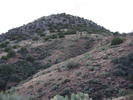 |
|
|
-
| 1 label | 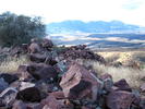 |
|
|
-
| |  |
|
2 |
-
| 1 label | 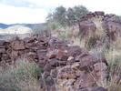 |
|
|
-
| 2 labels | 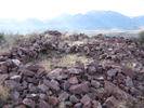 |
|
|
-
| 1 label | 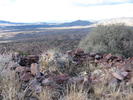 |
|
|
|
| | |
|
| Hiking | 2.00 Miles |
571 AEG |
| | Hiking | 2.00 Miles | 3 Hrs | | 0.67 mph |
| 571 ft AEG | | | | |
|
|
| |
| Linked |
|
none
[ show ]
| no linked trail guides |
| Partners |
|
none
[ show ]
| no partners | | | I did this hike with a different approach. It made the hike longer but eliminated much of the bushwhack. Just to the east of Black Mountain on Gisela Road you will find FR 554A. A 4 X 4 road, follow this road north past Black Mountain Tank and around the rear of Black Mountain and then it makes a U turn and heads straight for the north side of the mountain. The road ends and a cairned trail takes you the rest of the way up the steep mountain to the ruins. Check out the GPS route. A great day of exploring. |
| _____________________
It's best for a man to remain silent and be thought a fool, than to open his mouth and remove all doubt.
--Mark Twain |
| | |
|
|
|
|
|
| |
 Route Editor


