| | -
-
| 1 label |  |
|
1 |
-
| |  |
|
1 |
-
| 2 labels | 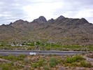 |
|
|
-
-
| 1 label | 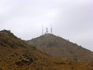 |
|
|
-
| 1 label |  |
|
|
-
| 1 label |  |
|
|
|
| | |
|
| Hiking | 11.75 Miles |
1,046 AEG |
| | Hiking | 11.75 Miles | 3 Hrs 39 Mns | | 3.22 mph |
| 1,046 ft AEG | | | | |
|
|
| |
| Linked |
|
none
[ show ]
| no linked trail guides |
| Partners |
|
none
[ show ]
| no partners | | I had planned to do a hike up in Yavapai County on Saturday, but PrescottStyle had to work.
Since the temperature was scheduled to top out at only 75° on Sunday — or 32° less than Friday’s record 107° — I figured I could hike locally, in comfort, without having to drive 3+ hours round trip to do it.
I thought about maybe doing something in the White Tanks or the Superstitions, but even those suburban mountain ranges are an hour away from my home in the central Phoenix neighborhood of Sunnyslope.
I could have hiked Shaw Butte Trail #306 from my house, but that is a hair under seven miles, and I did not want to find myself short of 50 miles at 6:00 p.m. on the last day of the month, like I did in April. 
I needed more miles.
So, I decided to hike the entire length of Charles M. Christiansen Trail #100 from the east to west.
Nothing new to add: It's Trail #100.
Temperature was 62° to start, and the sun only briefly peeked out while in the vicinity of Piestewa Peak.
I took a standup (so to speak) break at Dreamy Draw, and a sit down (to text my wife!) at NMVC.
Everybody was pretty cool, saying hello, and only one MTB blew by me.
Wife picked me up at bum-infested Mountain View Park, before we headed over to Tortas Reyes for lunch. 
Temperature is supposed to be low again on Tuesday, so I may do a Shaw Butte loop afterall.
-----
My last time looping Shaw Butte, I had stopped about every fifth of a mile to take a photo straight up trail. In my hike video, I timed each photo at two seconds. Today, I shot every two minutes. At my normal urban pace of ~3 mph, that would be a photo every .10-.12 miles, or 8-10 photos per mile. For an 11 mile hike, that would end up being 90-110 photos. Even at two seconds per photo, the resulting video would be 3-4 minutes long. That’s as long as my adventurous hikes, so I dropped the transitions between photos and set each photo to only one second. Not counting the title card at either end, the video is instead only 2:14 long. Let me know what you think!
Hike Video: [ youtube video ] |
| _____________________
| http://prestonm.com : Everyone's enjoyment of the outdoors is different and should be equally honored. |
| | |
|
|
|
|
|
| |
 Route Editor


