| | -
-
-
-
-
-
| |  |
|
2 |
-
-
-
-
-
-
-
-
| |  |
|
2 |
-
|
| | |
|
| Hiking | 8.00 Miles |
|
| | Hiking | 8.00 Miles | 4 Hrs | | 2.29 mph |
| 30 Mns Break | | | |
|
|
| |
| Linked |
|
none
[ show ]
| no linked trail guides |
| Partners |
|
none
[ show ]
| no partners | | According to the GCNP bulletin..."The Tuckup area is a remote, vast expanse of labyrinthine gorges, sandstone slickrock, and fascinating history. However, the unique combination of heat, unreliable water sources, and inaccessibility, makes this one of the most challenging and least visited of Grand Canyon’s named trails. In summer the sun and sandstone would cook even the hardiest desert creature, and winter access may be impossible due to heavy snow or mud. Spring or fall; after a rain is the best time to go, if you can get your vehicle out there. The easiest way to access this area is on the Tuweep road, just north of the Tuweep Overlook."
Having spoke with numerous park rangers, we (well, really, just I) fretted and fretted about making it out to Toroweap. But my other half (Blake) said "We have a high-clearance, 4WD vehicle with self-rescue equipment. We're going". And off we went! Not to dissuade folks from checking with park rangers about road conditions (it's recommended that you contact Pipe Spring National Monument), but the first approximate 60 miles could have been driven in a minivan. The road was dry and very nicely graded. The last three miles, though, are entirely another story. We did see a Subaru navigate the last bit, but I'm sure there were some serious scrapes on its underbelly. So, we'd say that high-clearance is a MUST.
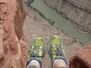
Upon reaching the campground, we hiked out to the overlook and dangled our feet over the 3,000 foot drop down to the Colorado.
We spent the night in a nicely secluded campsite (#10, if I recall correctly) and set off on Tuckup Trail (heading east) in the morning. The trail we hiked was actually an old road for the first three miles (although it didn't look like it had been driven on for numerous years) and so it was easy to follow. It was mostly slickrock and there wasn't much of an elevation gain or loss. We hiked until it was time for lunch, enjoyed our sandwiches in solitude, then turned around. We saw only two snakes (one was an enormous rattler hiding under a juniper  ) and two hikers. ) and two hikers.
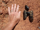
P.S. On the way to Toroweap we took a detour to see the Nampaweap rock art. Well worth the time spent. |
| _____________________
| Stephanie and Blake Barnard |
| | |
|
|
|
|
|
| |
 Route Editor


