| | -
-
-
-
-
-
-
-
-
-
-
-
-
-
-
| 2 labels | 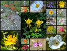 |
|
|
|
| | |
|
| Hiking | 5.25 Miles |
625 AEG |
| | Hiking | 5.25 Miles | | | |
| 625 ft AEG | | | | |
|
|
| |
| Linked |
|
none
[ show ]
| no linked trail guides |
| Partners |
|
none
[ show ]
| no partners | | The Area Closure for the Frye Fire has been reduced by 23,000 acres as of August 30, 2017.
Mostly the Stockton Pass area on the south side has been the re-opened area, but also Twilight Road/Campground going up 366.
Twilight is what I wanted to see especially the grand view of Hielograph Peak at the road/trails end.
I knew it would be a terrible day to go up for encountering the holiday crowds and it was, we won't talk about that ](https://hikearizona.com/dex2/images/smilies/eusa_wall.gif "Brick wall")
Parked at Turkey Flat and first hiked the road and foot trail around the mountain to the Hielograph view.  What can I say, seeing these new burned areas for the first time is gonna suck for many years to come. Not as bad as expected, but the fire did (as FS said) burn in a mosaic pattern leaving a mixture of burn & green all down the peak, ridgeline & valleys. What can I say, seeing these new burned areas for the first time is gonna suck for many years to come. Not as bad as expected, but the fire did (as FS said) burn in a mosaic pattern leaving a mixture of burn & green all down the peak, ridgeline & valleys.
I then hiked back around and up to Twilight Spring. Beautiful trail as always that left the crowds and burn behind. Love this old growth forest that was full of green, bare berry patches & big bear poo all the way to the spring. The spring area now has some flooding damage, but is still there and it looked like I just missed a great sunflower & fern show.
Returned back to the start after seeing what I came for and in a big hurry got the H off that mountain and away from the holiday noise.
Wildflowers were a very good show along the road and into many sections of the mountain.
Wildlife was slow today, except for all the barking dogs!
 |
|
Wildflowers Observation Moderate
Rainbow of colors along Twilight road. |
|
| _____________________
| | |
|
|
|
|
|
| |
 Route Editor


