DESTINATION Generic 106 Photosets
| | -
| 1 label | 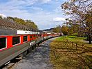 |
|
|
-
| 1 label | 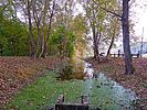 |
|
|
-
| 2 labels | 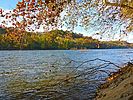 |
|
1 |
-
| 1 label | 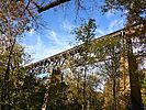 |
|
|
-
| 1 label | 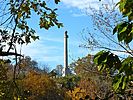 |
|
|
-
| 1 label |  |
|
|
-
| 2 labels |  |
|
2 |
-
| 2 labels |  |
|
|
-
| 1 label |  |
|
|
-
| 1 label | 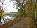 |
|
|
-
| 1 label | 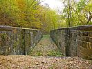 |
|
2 |
-
| 1 label |  |
|
|
-
| 1 label | 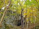 |
|
|
-
| 1 label | 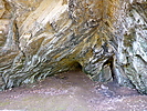 |
|
|
-
| 1 label |  |
|
|
|
| | |
|
| Hiking | 9.06 Miles |
275 AEG |
| | Hiking | 9.06 Miles | 3 Hrs 6 Mns | | 2.92 mph |
| 275 ft AEG | | | | |
|
|
| |
| Partners |
|
none
[ show ]
| no partners | | Last year, I hiked milepost 61-69, from Maryland Heights to Antietam Aqueduct. [ photoset ] Continuing northwest, this year I hiked milepost 69-77, from Antietam Aqueduct to Snyders Landing. 
There is very little elevation gain on the C&O Canal towpath, even hiking ‘uphill’: The eight miles from milepost 69-77 only gain 55 ft. (My 275 AEG on the day, is due to climbing down to the Potomac River, or up to Killiansburg Cave.) So, hiking the C&O Canal either direction saves no appreciable effort. Besides hiking south, other options for those without a shuttle driver, include hiking Antietam Aqueduct to the Rumsey Bridge trailhead (6.6 mi.) and Snyders Landing to the Rumsey Bridge trailhead (8.4 mi.)
The quarter mile section of the C&O Canal between Antietam Aqueduct and the campground was filled with water. The remainder of the old canal bed varied from dry to soggy, depending on how exposed to the sun a section is.
The Antietam Creek Campground has 20 numbered spots, each with a firepit, grill and picnic table. The campground has a well handpump, pit toilet and several portapotties. The fee is a whopping $20/night and stealth camping is illegal. 
Between Antietam Aqueduct and Rumsey Bridge, the north side of the C&O Canal is paralleled by Canal Rd. From Rumsey Bridge to Snyders Landing, the side opposite the towpath is bluffs & cliffs.
Just short of Packhouse Ford, on the other side of Canal Rd., there is a large, sloped lawn. At the bottom of the hill is a pond, and atop it is the Conococheague Sportsmens’ Club. Thankfully, despite the presence of numerous loud geese, the firing range is in back.
Packhouse Ford, also know as Boteler’s Ford and Blackford’s Ford is a rocky, hip-deep (under normal conditions), Potomac River crossing used numerous times during the Civil War, when the Union was invading Virginia, or the Confederates were invading Maryland.
My wife met me at the C&O Shepherdstown Trailhead, a half mile short of Rumsey Bridge. I topped off my water, then continued on. (There is another trailhead at the bridge, beside Lock 38.) Between the two trailheads, there are four bridges: The old railroad bridge, the current Norfolk Southern Railroad bridge, the old Rumsey Bridge and the new (c. 2006) Rumsey Bridge. On a bluff across the Potomac River, is the Rumsey Monument, dedicated to James Rumsey who, in Shepherdstown, in 1787, 20 years before Fulton, built the first successful steam engine.
From Rumsey Bridge, the C&O Canal towpath passes Ferry Hill, before arriving at Lock 39. There were a number of use trails from the towpath up the bluffs to Snyders Landing Rd.
The Killiansburg Cave Campground, at milepost 75, has only one spot, but at least is free, not a wallet gouging $20. There is also a picnic table, firepit, well handpump and portapotty.
A quarter mile on, I spotted two small caves, which I later found out are the Snyders Landing Caves. The one on the right I had to crawl into; the one on the left, I could stand up. Neither went more than 30 ft. into the bluff.
A couple hundred yards further, halfway up the bluff, is Killiansburg Cave, a large hole where the citizens of Sharpsburg sheltered from the battle.
From Killiansburg Cave, it is only another mile to Snyders Landing. I had hoped to stop at nearby Barron’s C&O Canal Museum for a post-hike ice cream, but unfortunately they are only open on weekends.   
Hike Video: https://vimeo.com/494811432 |
|
Autumn Foliage Observation Moderate
Lots and lots of yellow, fading to brown, with many leaves already on the ground. No red or orange at all. This year, Halloween was a week past peak fall color in Washington County and Allegany County. |
|
| _____________________
| http://prestonm.com : Everyone's enjoyment of the outdoors is different and should be equally honored. |
| | |
|
|
|
|
|
| |
 Route Editor


