| | -
-
-
-
| |  |
|
3 |
-
-
| 4 labels | 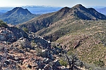 |
|
|
-
-
|
| | |
|
| Hiking | 24.06 Miles |
5,235 AEG |
| | Hiking | 24.06 Miles | 7 Hrs 32 Mns | | 3.42 mph |
| 5,235 ft AEG | 30 Mns Break | | | |
|
|
| |
| Partners |
|
none
[ show ]
| no partners | | Wanted to get one last big hike in this year but was a little pressed for time, so instead of trying to come up Deer Creek I took the veritable highway Gold Ridge Trail out and back on a trip up Mount Peeley. I had hiked and driven every stretch of this route independently before, but it still impressed.
Got to the trailhead at dawn, and two bow hunters were just about to start their day. Went up to Gold Ridge hoping they weren't headed that way, but they were. Bummer for those guys. Didn't see any deer anyway, so maybe not.
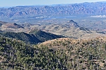
Started the climb up Gold Ridge and the trail was recently worked. Brush is trimmed and the surface is the least slippery I can remember it. After the main ascent on Gold Ridge at about 3.5 miles the A1 Mazatzal views reveal themselves and don't let up for the rest of the trip to the summit.
There is a fallen tree blocking the upper trailhead at the end of 3348 where the best campsites are. Not sure it'd take much to move it.
201 is a beautiful necessary evil: not a huge fan of hiking roads, but the views into the heart of the Mazatzals render this moot. Plus with the dense pines there remains some of the pre-Willow beauty. Only people I saw all day were four gentlemen driving to the Peeley TH and then on to the Sunflower Mine. Chatted for a bit, took their picture, and headed up.
Took the Mazatzal Divide Trail around to the north side of the peak to avoid shorter but steeper and brushier alternatives. Hazy views toward the city, and the sun washed out the views to the south, but just about perfect weather on top.
Headed back down the way I came and hurried back to the city. Few trees down on the upper end of Gold Ridge and on the Maz. Divide Trail, but otherwise the trip was obstacle free. |
| | |
|
|
|
|
|
| |
 Route Editor


