| | -
| |  |
|
1 |
-
-
-
-
-
-
-
-
-
-
-
-
-
-
|
| | |
|
| Hiking | 14.89 Miles |
3,563 AEG |
| | Hiking | 14.89 Miles | 7 Hrs 54 Mns | | 2.14 mph |
| 3,563 ft AEG | 56 Mns Break | | | |
|
|
| |
| Partners |
|
none
[ show ]
| no partners | | My son and I set off from the Canyon Lake Marina just before 7 am. The “in” gate to the marina doesn’t open till 8 am, but entering through the exit gets you to the parking area.
Temps were a little chilly, but the 700 ft climb right out of the gate gets the blood pumping.
By the time we crested the initial hill, the coming dawn opened up a nice view back toward the lake with a pinkish hue on the northwestern horizon.
At the Indian paint mine, we ran into our first company—a couple of guys who were planning to hit up the Battleship. We informed them they missed their turn. We told them we were headed there, but they could also circle back on the LaBarge side. They decided to head that direction, and we parted ways.
From the paint mine to the second water trail junction was the coldest section of the hike. We still hadn’t seen the sun but were anxious to meet it past the second water junction.
About 1/4 mile before the turn up to Battleship, we met a couple more hikers who were backtracking in the opposite direction—also headed to Battleship and thinking they had missed the optimal turn up. I told them they were welcome to try their luck wherever, but suggested that the easier routes still lay further down a bit. They were convinced and trailed us to our chosen turn up—which incidentally is somewhat before the one reflected on the official HAZ route.
We were happy with our choice, which ended up being a pretty clear and well cairned route.
Clambering across the spine turned out to involve a bit more scrambling than I had recalled, but was a lot of fun.
We made it to the summit and had it to ourselves for 15 minutes or so until our trailing hikers arrived. After a bit though, we could see that Battleship was shaping up to be a popular destination on the day—with several groups making their way across the spine.
After backtracking across the spine, we swung east and dropped down into the LaBarge drainage. This was a section I hadn’t previously hiked, and it was the gem of the trip for me. The route down to the Box was clear and didn’t require any bushwhacking.
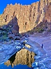
At the entrance to the Box was a large pool of water next to a fantastic camping spot. The shaded pool was a perfect reflection pond for the west-facing cliff face that was drenched in afternoon sun. We took lots of pictures and had a great time exploring up the Box. Lots of pools and plenty of water for filtering. What a cool area—definitely exceeded my expectations.
After taking in our fill of the Box, we tackled the northbound route through LaBarge. This involved a little bushwhacking, and boulder hopping, but again was more tame than anticipated.
Once we reconnected with the actual trail, we cruised back to the trailhead.
Turned out to be another great day in the Supes. |
| _____________________
| | |
|
|
|
|
|
| |
 Route Editor


