| | -
-
-
-
-
| 1 label | 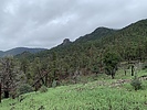 |
|
|
-
-
-
| 1 label |  |
|
|
-
| 1 label | 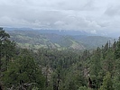 |
|
|
-
| 2 labels | 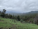 |
|
|
|
| | |
|
| Hiking | 3.43 Miles |
1,281 AEG |
| | Hiking | 3.43 Miles | 2 Hrs 56 Mns | | 1.70 mph |
| 1,281 ft AEG | 55 Mns Break | | | |
|
|
| |
| Linked |
|
none
[ show ]
| no linked trail guides |
| Partners |
|
none
[ show ]
| no partners | | This trail also falls into the category of, why did I not hike this trail sooner? Although, it was learning about recent trail maintenance on the trail that spurred my interest, so our experience may not have been as popular had I tried hiking this one years ago.
The trail drops steeply and was in generally good shape, with a solid, but thin tread in spots. Some locust and oaks are starting to crowd the top near the initial descent, but the rest of the trail was clear and smooth sailing. The views from the trail were pretty spectacular and I agree with the FS assessment that it may offer the best panorama views of the Blue. In particular, the up close views of the prominent Castle Rock. We meant to hike further, but got distracted by the beautiful sound of running water in a drainage near the trail. We spent more time playing in the water than we should of and then some nasty clouds and sprinkles convinced us it was time to head back. |
| _____________________
| | |
|
|
|
|
|
| |
 Route Editor


