| | -
-
-
-
| |  |
|
4 |
-
-
-
| 1 label | 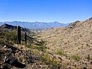 |
|
|
-
-
-
-
| 1 label |  |
|
2 |
-
| 1 label |  |
|
|
-
-
-
| 1 label | 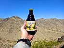 |
|
|
|
| | |
|
| Hiking | 7.79 Miles |
1,497 AEG |
| | Hiking | 7.79 Miles | 3 Hrs 11 Mns | | 2.45 mph |
| 1,497 ft AEG | | | | |
|
|
| |
| Partners |
|
none
[ show ]
| no partners | | Every winter, to avoid burning out an area, I rotate through the Valley of the Sun’s various mountain preserves and regional parks. This week, it was South Mountain’s turn.
It’s been two years since I hiked the west end of the park, when I did the last of my ten Loop 202 South Mountain Freeway survey hikes: [ photoset ] . Today’s plan was to hike Pyramid Trail, Lost Ranch Mine Trail, Gila Trail and Bursera Trail counter-clockwise. The loop is 5.8 miles, 1,150 AEG. With Lost Ranch Ruins and Bursera Peak it is 6.5 miles, 1,350 AEG. As usual, my stats are greater due to exploring along the way.
Pyramid Trail, it was wide, gravelly, and rolling.
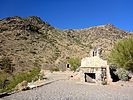
Lost Ranch Mine Trail was pretty darn rocky: Okay for hiking, but I wouldn’t want to endure the jarring of mountain biking it. I couldn’t find any info online about Lost Ranch’s history, but it was a big place, with a concrete foundation, local stone walls, and multiple fireplaces. After checking out Lost Ranch, I doubled back to the wash, then picked up Gila Trail.
Gila Trail climbs 360 ft. in ¾ mile to a saddle. At the saddle, there is a yellow “area closed” sign. Opposite the sign, is a use-trail up. That is the shortcut to Bursera Trail.
Gila Trail continues down, to the west. It was initially steep and rocky. After the first of two deep washes, the trail surface cleared and leveled out. I saw a mine adit up the first wash, but it only went in maybe 10 ft. I think it was a prospect, not a collapsed tunnel.
I continued on Gila Trail for ⅓ mile past the Bursera Trail intersection to a knoll above the luxury community recently built next to Ed Pasor Freeway. After enjoying half my gas station murderwich, I doubled back to Bursera Trail.
Bursera Trail is a smooth single track, dotted with small sections of exposed bedrock. From Gila Trail, it climbs 360 ft. in ¾ mile to a south-facing saddle. Same distance & angle as Gila Trail, but it seemed steeper. Bursera Canyon Trail descends south; instead, turn left. Bursera Trail continues climbing, 180 ft. in ⅓ mile to this loop’s high point: The upper end of the shortcut.
Just before the shortcut, there is a faint trail on the right that goes to the summit of Bursera Peak. (Note: The actual summit is ⅓ mile west of where the satellite view claims it is.) The summit is not very high off Bursera Trail, but it does have good views and space for a picnic. 
From the summit, other than stopping to attempt a repair on my pack’s zipper, I slalomed past a steady stream of people heading up, making it down to Bursera Trailhead in about 30 minutes.
Hike Video: https://vimeo.com/669126156 |
|
Wildflowers Observation None
El zilcho. |
|
| _____________________
| http://prestonm.com : Everyone's enjoyment of the outdoors is different and should be equally honored. |
| | |
|
|
|
|
|
| |
 Route Editor


