| |
| Holdout-Blackrock Loop, AZ | | -
-
| 1 label | 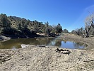 |
|
|
-
-
-
| |  |
|
2 |
-
-
-
-
-
-
-
-
-
-
|
| | Holdout-Blackrock Loop, AZ | | | |
|
|
Holdout-Blackrock Loop, AZ
| | |
| |
| |
| Partners |
|
none
[ show ]
| no partners | | I decided to see how the Santa Teresas faired after 2021's Pinnacle Fire by backpacking a loop of Holdout and Blackrock canyons. I had planned on driving up FR-6630 (the GET) and parking at a pull-off near some trees about 3/4-mile before the gate. This spot was previously recommended to me by the guy who ranches this area and my Subaru had made up there before just fine. However, after about 1/2-mile from leaving Klondyke Rd, there is a large gash in the road (I'm guessing made by 2021's summer monsoons).
Not wanting to risk trying it in my Subaru by myself, I made a 27-point turn on the narrow road and returned to Klondyke Rd. I drove North a very short distance, turned onto the next gated forest road (can't find its name) and parked my car at the first pull-off. This was spot was also recommended to me by the rancher. As luck would have it, that same rancher pulled up just as I was getting out of my car. He recognized me and offered me a ride up the road, eventually dropping me off near Reef Tank where I began hiking. Thank you! This saved me a ton of hiking and uphill.
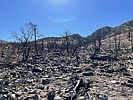
Reef Tank had some water in it and the area around it was unburned. Heading up the saddle before going into Holdout Creek, you quickly enter the burned area. Everything around here has been moon-scaped. The trail isn't too hard to follow though. Going down Holdout Creek, it seems most everything near the creek is completely burned, while rockier areas appear to be untouched. It's still a pretty and scenic canyon, but the wonderful forest surrounding the creek is gone. The fire has made travel through Holdout easier for now - the path is much less brushy. I still lost the trail many times and got some scrapes from catclaw though. I expect that within a few years or less, the path will be overgrown with catclaw and manzanita. Holdout Creek had some water flowing down it, although it looked quite brownish.
I made it to the corral area near the Holdout and Blackrock intersection and made camp for the night. The creek intersection seemed much sandier than what I remember - debris being washed down from monsoons in the burn areas? I had a peaceful night aside from some cows wandering near my camp. I woke up early the next morning and began hiking up Blackrock Canyon. Blackrock has also been burned and I followed some combination of cow paths and hiking trails. The water in Blackrock was much clearer than Holdout and the flow seemed pretty good. After a mile or less, I hiked out of the burn zone. The next miles up Blackrock make for some great hiking through a beautiful forested canyon. This was my favorite section of the trip.
Hiking out of Blackrock, I made use of forest roads to make my way back to Reef Tank, where I then took the GET back down to Klondyke Rd. This section of the GET (from Reef Tank down to the road) is unburned. It's hard to follow and brushy, but the trail usually exists somewhere. Once back to the gate on FR-6630, I had the long descent back to Klondyke Rd and my car. |
  |
Reef Tank |
26-50% full |
26-50% full |
| | | Maybe 1/3rd full? Water seemed decent | | _____________________
| | |
|
|
|
|
|
| |
 Route Editor


