| | -
-
-
-
-
-
-
-
| |  |
|
10 |
-
-
| |  |
|
4 |
-
-
-
-
-
|
| | |
|
| Hiking | 10.30 Miles |
1,517 AEG |
| | Hiking | 10.30 Miles | 5 Hrs 51 Mns | | 2.05 mph |
| 1,517 ft AEG | 49 Mns Break | | | |
|
|
| |
| Linked |
|
none
[ show ]
| no linked trail guides |
| Partners |
|
none
[ show ]
| no partners | | I made yet another trip up to the Monument today with Katie. We checked off the Black Mesa Fort/ruins and then continued on to Black Mesa proper to check out an interesting site Larry and I had been a little curious about after coming across a few references to it and finding it on satellite imagery.
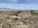
We had initially planned to approach the Black Mesa Fort by the suggested some users had posted in previous triplogs, but as we neared, I noticed the approach from the 17 was fully shaded and not overly steep looking, so we committed to the dicey pullout. From the pullout, we paralleled the highway on the other side of the guardrail for a bit, hit the old road and then started up an obvious ridgeline to the obvious break. A pretty good use trail took us to the break and the ruins are basically right there when you top out. These are a great set of ruins. Some of the best pueblo style ruins in the area for sure and what a view. I think the Perry Mesa archaeological guide includes these ruins as part of the Perry Mesa groups up there, but I would like to look into that more and see if I can find anything more substantive on the ruins. After marveling over the ruins for a several minutes, we headed north to Black Mesa proper.
We did not find the travel to the rim of Black Mesa, to be overly tedious and I think we took the most natural line, as it was dotted with ancient glyphs and sheep herder or cattleman graffiti from the early 20th century. After reaching the top of the mesa, we took a generally direct line towards our ruins site and then used the road under the powerlines to finish the final mile or so to the ruins. Travel on the mesa in that particular area is not overly tedious, however, the road was a welcomed relief and and we made good time each way on the road. The large circular ruins that we had observed from satellite imagery appeared to be something more contemporary than ancient ruins and probably related to ranching, however, the more contemporary walls may have been built from an ancient ruin as there were several glphys in the area, metates, a few pieces of pottery and maybe some signs of an ancient check dam or some other ancient/contemporary water harnessing project. After spending some considerable time at the site we returned via the same road. However, on the return we stayed on the road and did not traverse over to the same point we came up from. The road actually took us all the way back to where we parked on the highway and saved us from any off trail walking on the return.
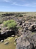
A beautiful day up on Black Mesa. The desert was popping and in full bloom along the approach and the some wispy clouds and nice breeze made our time on the mesa enjoyable. Likewise, the off trail travel was less tedious than other parts of the monument. The gamble on the road return paid off and it took us through a deceptively scenic stretch of desert, we would have otherwise never known existed. |
|
Wildflowers Observation Light
The desert was in full bloom along the approach to Black Mesa and on our road walk return. |
|
| _____________________
| | |
|
|
|
|
|
| |
 Route Editor


