| | -
-
-
-
-
| |  |
|
1 |
-
-
-
-
-
-
-
-
-
|
| | |
|
| Hiking | 2.50 Miles |
1,700 AEG |
| | Hiking | 2.50 Miles | 1 Hour | | 2.50 mph |
| 1,700 ft AEG | | | | |
|
|
| |
| Linked |
|
none
[ show ]
| no linked trail guides |
| Partners |
|
none
[ show ]
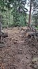
| no partners | | Myself and 7 volunteers were out on upper and mid Shake the weekend of June 18 and 19th 2022. We cleared brush in some manzanita and madrone overgrowth areas. We also worked to rake out the tread of piney debris and restored the tread about 1 mile in from the upper trail head as it had completely faded near a meadow. 3-4 downed trees were hand sawed out. Got hailed on both days coming back up to the car as some pretty good t-storms rolled through. This makes for a great summer out and back hike 2.5mile round trip with about 1700 foot of gain.
The trail below the 2.3 mile mark has a number of tread creep, drainage and braiding issues. One section of the trail near the creek at around mile 2.4 was nearly completely gone to tread creep. I benched that section back into the hillside so you won't slide down the hill trying to get through that section. The lower 2.5 miles need more work but it's in quite good shape for a Mt Graham trail. Hope to get some more work done this winter on the lower section of Shake and Bear. Our next volunteer trail maintenance day will be Aug 20-21 on the middle section of Bear Canyon Trail.
Note: I added a route to this triplog with the current GPS track of the entire trail from top to bottom. This GPX file was shared by a buddy who biked through the trail from top to bottom. I'm sharing this because most of the existing tracks on Hike AZ and other sites using OSM are currently incorrect. The upper trail head is about 3/4 mile further up the Swift Hwy headed toward Shannon Campground. There's a paved pull out on the left hand side of the hwy. In the woods there is a Shake Trail sign and then another sign which indicates it's current actualy mileage which is 5.1 miles. The trail loses about 3100ft of elevation. Good stuff to know. Have fun out there. Update: It looks like HikeAZ adopted my GPX track submission as the official route. I would cauation that is probably not accurate at a granular level but it should be much more accurate than what was previously shown.
Want to get involved with trail work?
↓ See my signature below ↓ |
|
Wildflowers Observation Moderate
|
|
| _____________________
Sonoran Desert Mountain Bicyclists
Mt Graham Volunteer Trail Work Coordinator
Want to volunteer? Email: communications@sdmb.org
Instagram @sdmb_mtb |
| | |
|
|
|
|
|
| |
 Route Editor


