DESTINATION Generic 204 Photosets
| | -
| 2 labels | 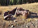 |
|
|
-
| 1 label | 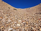 |
|
|
-
| 1 label | 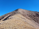 |
|
|
-
| 2 labels | 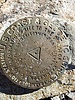 |
|
|
-
| 5 labels | 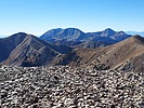 |
|
|
-
| |  |
|
1 |
-
-
| |  |
|
1 |
-
-
-
| |  |
|
1 |
-
| 1 label | 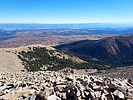 |
|
|
-
-
| 1 label | 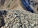 |
|
|
-
| 2 labels | 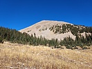 |
|
|
|
| | |
|
| Hiking | 6.19 Miles |
2,470 AEG |
| | Hiking | 6.19 Miles | 4 Hrs 31 Mns | | 1.59 mph |
| 2,470 ft AEG | 37 Mns Break | | | |
|
|
| |
| Linked |
|
none
[ show ]
| no linked trail guides |
| Partners |
|
none
[ show ]
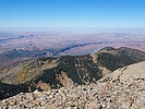
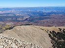
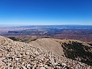
| no partners | | This was a hike to the summit of Mount Waas (elevation of 12,331 feet and prominence of 1,793 feet), which is in the stunningly beautiful LaSal Mountains near Moab, Utah. Mount Waas is the highpoint of Grand County, which is one reason that it was on my radar screen.
I came in through Beaver Basin. I was originally planning to hike from Miners Basin, but I called the Moab Ranger District and they said that the road in from Miners Basin was really rough, and they encouraged me to hike from Beaver Basin instead.
The road into Beaver Basin was an easy drive to the turn for Don's Lake, but it got rougher after that, eventually needing 4WD. I got tired of driving the narrow, rocky road and came to place to pull out and park, which is what I did. I started the hike from there, and actually the road got better, and I could have driven another 1.75 miles, but then it would have only been about a 2.5 mile hike.
The hike on the road was scenic, so I am glad that I started where I did. Eventually I left the road and began hiking out of Beaver Basin to a saddle between Mount Waas and an unnamed peak at 12,163 feet that has a weather station on it. The first part of the ascent out of Beaver Basin was through a forest that was fairly easy to go through. Then I got out of the forest and made a fairly steep ascent through a bit of talus and scree to the aforementioned saddle. From the saddle, it was a steep ascent through talus to the summit of Mount Waas. Fortunately, there was an easy to follow "trail" through the talus that had lots of switchbacks. I took my time and made my way to the summit. I enjoyed the great views, and then went back the way that I came.
I enjoyed this fairly short hike -- it was a bit steep climbing out of Beaver Basin, but the views at the summit made it worthwhile! |
|
Autumn Foliage Observation Light
There are still some pockets of nice golden aspen leaves, but most are past prime and many leaves have fallen off the trees. |
|
| _____________________
| Civilization is a nice place to visit but I wouldn't want to live there |
| | |
|
|
|
|
|
| |
 Route Editor