| |
| SalomeWildCyn-ViewPt KNOB 5344ft, AZ | | -
-
-
| |  |
|
1 |
-
| 1 label | 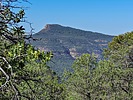 |
|
|
-
-
-
| |  |
|
1 |
-
| 2 labels | 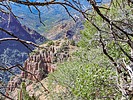 |
|
|
-
| 3 labels | 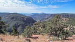 |
|
|
-
-
-
-
| |  |
|
1 |
-
| 1 label |  |
|
|
|
| | SalomeWildCyn-ViewPt KNOB 5344ft, AZ | | | |
|
|
SalomeWildCyn-ViewPt KNOB 5344ft, AZ
| | |
|
| Hiking | 6.27 Miles |
1,215 AEG |
| | Hiking | 6.27 Miles | 8 Hrs 15 Mns | | 0.90 mph |
| 1,215 ft AEG | 1 Hour 19 Mns Break | | | |
|
|
| |
| Partners |
|
[ show ]
| partners | | Grasshopper has been pestering me for about 3 years to go on this hike. He seems to have an obsession with hiking to remote viewpoints of Salome Canyon in the Salome Wilderness. This is one of the few areas of the Sierra Ancha we have not explored so I was all in favor of this endeavor. We finally had an opportunity when someone, or a flash flood, removed some boulders blocking the 4WD track, FR2752, into Park Tank allowing us to set up our car camp close enough to his desired destination for a day's hike that would be within our limitations.
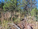
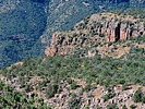
I had plotted a planning gps track on Google Earth attempting to avoid brush thickets and cliffs as much as possible. Unfortunately, the views on GE of much of the route up to the top of the ridge we would follow were obscured by trees and brush. The morning of the hike I decided to abandon part of the planning track for a route straight up to the top of the ridge from our campsite. This route had the advantage of using a gate in the barbed wire fence-from-H*** near camp. It also would give some views into Park Canyon. We soon discovered the error in this plan after dodging rock outcroppings and thrashing through thick brush to reach the ridgetop. We had hoped to find clearings along the top of the ridge but they were few and far between until we reached the point a mile later where the planning track arrived at the ridgetop. Our route along the ridge as it neared our destination did provide come good views into the confluence of Workman Creek with Salome Creek and passed through a number of small meadows covered with yellow flowers. After descending about 500 ft along the ridge we reached the top of a steep slope looking down on our final destination and discovered that we would have to climb back up an additional 500 ft on the return hike plus thrash through a lot more brush to get there and back. Deciding we didn't have the time or energy to do this, we made this "alternate" viewpoint our turn around point.
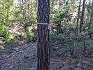
On the return hike back up to the top of the ridge we decided to abandon trying to backtrack on our incoming gps track and just follow the cow trails. We soon discovered the cows were expert at avoiding the brush and finding grass covered clearings hidden in the trees. The only negative about the cow trails were the low hanging branches they passed under at about head height for us humans. We, mainly GH, kept bonking our heads on these obstructions. The cows' path finding skills ended up leading us away from our in-coming track to a well worn cow trail descending at a gentle grade directly back to the fence gate near camp. The beginning of that trail was even marked with a ribbon tied around a tree, probably by the cattle rancher with the grazing lease for this area. This reduced our return time by about an hour getting us back to camp before GH turned into a pumpkin. Unfortunately we had to give up searching for GH's cell phone on the rough section of our incoming track where he had lost it that morning. However at this point neither of us were feeling lucky. And, GH had put a higher priority on getting back in time for his afternoon bath in camp and fixing a big supper while I was thinking about that cold beer waiting for me. Later, looking at my GPS topo I discovered that by pure coincidence my original planning track had followed that cow path, which wasn't visible on GE, up the hillside. ](https://hikearizona.com/dex2/images/smilies/eusa_wall.gif "Brick wall") |
| _____________________
| | |
|
|
|
|
|
| |
 Route Editor


