| |
| Mound Mountain via Rogers Trough, AZ | | -
-
-
| 1 label | 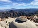 |
|
|
-
-
-
-
-
| |  |
|
1 |
-
|
| | Mound Mountain via Rogers Trough, AZ | | | |
|
|
Mound Mountain via Rogers Trough, AZ
| | |
|
| Hiking | 19.70 Miles |
3,750 AEG |
| | Hiking | 19.70 Miles | 9 Hrs 47 Mns | | 2.13 mph |
| 3,750 ft AEG | 31 Mns Break | | | |
|
|
| |
| Partners |
|
none
[ show ]
| no partners | | Mound has been on the list for some time. While 172A was unpleasant, an old Chevy Suburban made the trip just fine. There are a few spots along Reavis Ranch & Fireline that are pretty damaged and require a little more attention. This was the furthest East I have ventured in the Superstitions and I really enjoyed it. Hopefully the 88 is repaired someday and I can take advantage of easier access.
I have been aware of this peak for a few years and heard mixed reports on peak views. I was pleasantly surprised. You get a great view of four peaks from behind and most of the Superstition Ridgeline is visible off to the West. There were quite a few ladybugs on top. Peak ladybugs are always welcome.
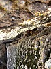
We saw several White-tailed deer. No bears. Lots of cat tracks.
I should also mention that it looks like the trip register on the peak was destroyed. Looks like a glass container that shattered some how. If there is another register up there, I did not find it. |
| _____________________
| | |
|
|
|
|
|
| |
 Route Editor


