| | -
| 1 label | 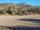 |
|
|
-
-
-
| 1 label | 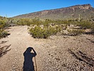 |
|
|
-
| 1 label | 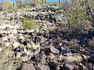 |
|
|
-
-
| 1 label | 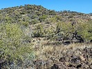 |
|
|
-
| 1 label | 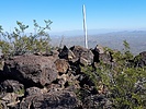 |
|
1 |
-
-
-
| 2 labels | 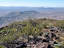 |
|
|
-
| 2 labels | 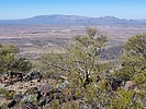 |
|
|
-
| 1 label | 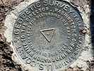 |
|
|
-
| 1 label | 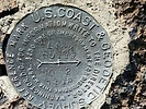 |
|
1 |
|
| | |
|
| Hiking | 8.15 Miles |
1,629 AEG |
| | Hiking | 8.15 Miles | 5 Hrs 8 Mns | | 1.85 mph |
| 1,629 ft AEG | 43 Mns Break | | | |
|
|
| |
| Linked |
|
none
[ show ]
| no linked trail guides |
| Partners |
|
none
[ show ]
| no partners | | Just what Arizona needs -- another peak with "Black" in the name. I have lost track of the number of peaks that I climbed that are named "Black Mountain", "Black Mesa", "Black Butte", "Black Peak", etc. I believe that over 100 places in Arizona use the word "Black". Often the name designates a volcanic area, and this one is no exception -- there are LOTS of black basalt rocks littering the landscape.
This particular Black Butte is in the far western part of Maricopa County, southeast of the town of Aguila. In other words, it is in the middle of nowhere. The Black Butte summit is at an elevation of 3,612 feet and it has prominence of 1,092 feet.
I like to avoid driving on I-10 when possible, so I drove through Wickenburg and then took Highway 60 going SW. Near the town of Aguila I took Eagle Eye Rd to Aguila Rd. Aguila Rd. is not paved, but it is well graded and I was able to drive 40-50 mph on it. I then took a road underneath a powerline for about 1/2 mile, and then took another dirt road for 2 miles, when I parked just before a wash. The powerline road was a bit rough and rocky, but the second road was one that a crossover SUV could easily drive on.
This put me due south of the peak. For the hike, I continued walking on the road for about 3/4 mile when it ended; then walked through a wash; then walked on another road to the base of a ridgeline SW of the summit. All told, I hiked about 2.5 miles getting to the base of the ridgeline. Then I hiked on the ridgeline for about 1.5 miles to get to the summit.
The ridgeline was nice and wide and was class 1 hiking. However, there were many basalt rocks and small boulders littering the landscape on the way. At times I was just walking from one rock to another, with my feet never touching dirt. At other times, I could walk on the ground and avoid the rocks. The going was steep, but not unreasonably so. However, with all of the rocks and small boulders, the going was slow.
I eventually made it to the summit, and took a lunch break up there. It was hazy, so the views were not as nice as they might have been. I located the benchmark, one reference mark, the height-of-light remants, and summit register log. I did not see the second reference mark, but I did not spend a lot of time looking for it.
I went back the way that I came up. The first mile of the descent on the ridgeline was OK, but over the last 1/2 mile on the ridgeline I grew tired of the rock and boulder hopping, and I was glad to finally make it back to the road.
Synopsis
The hike was OK, but wasn't the most exciting hike that I have ever done. The desert out there is almost exclusively saguaros, palo verde trees, creosote bushes, and cholla; so I did not find it particularly interesting. The geology is not that interesting out there either, unless you are a big fan of basalt rocks and boulders. I am glad that I did this one, but I don't have any real interest in doing it again. |
| _____________________
| Civilization is a nice place to visit but I wouldn't want to live there |
| | |
|
|
|
|
|
| |
 Route Editor


