| | -
-
-
-
-
-
-
-
-
-
-
| 1 label | 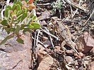 |
|
|
-
-
-
| |  |
|
3 |
-
|
| | |
|
| Hiking | 12.56 Miles |
2,126 AEG |
| | Hiking | 12.56 Miles | 6 Hrs 36 Mns | | 2.20 mph |
| 2,126 ft AEG | 54 Mns Break | | | |
|
|
| |
| Linked |
|
none
[ show ]
| no linked trail guides |
| Partners |
|
none
[ show ]
| no partners | | It was my first time on Barnhart Trail. Arrived at the trailhead at 8:30 and there were a lot of cars already there. The trail is really rocky and not easy to walk on at the start, but it isn't long before it gets better. Slope starts out pretty gentle as you follow the canyon to the West. In the canyon the sun was already beating down on us even in the morning and it felt like it was going to be a hot day. The trail parallels the canyon a few hundred feet up from the river which could be seen occasionally. After a mile and a half the trail starts climbing. Gently at first and eventually steeper. At one point the trail is level with and heading towards waterfalls, but the trail keeps climbing and never gets close to those falls. There are a bunch of switchbacks and there are views of the trail we started on a long way below, and it still keeps climbing. There are several shady stretches on this part of the trail because the cliffs are nearly vertical and hide the sun. Very pleasant to rest in the shade. There are also some streams with little waterfalls that cross the trail. The shady, wet trail is cool, green and lush.
After some more climbing we reach the waterfall. It's flowing pretty good. Not as much as I've seen in some photo sets, but enough to be worth the long hike up. The main waterfall that drops down a vertical slit in the cliff can be seen from the trail, but you have to climb up over some boulders to get right up to it. Very cool seeing all this water in the desert.
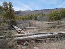
Our original intent was to do the Barnhart - Sandy Saddle loop. Looks good on the map. But we met some hikers who let us know that Sandy Saddle trail is not maintained and is overgrown and not fun. Oh well. After a rest at the falls we continued on up Barnhart Trail looking for the junction with Sandy Saddle. After getting to the top the trail stays more or less level on the plateau. A large Horned Toad lizard welcomed us to this part of the trail. In the first stretch the manzanita have grown wild on either side of the trail leaving just a narrow single track passage. Then it opens up and there are lots of burned dead trees. Above the trail there are hundreds of downed trees all over the place. There are a couple of places where you can see lots of big trees, but mostly the hills are covered with dead wood and lots of low brush.
Eventually we got to the intersection with the Arizona Trail which is marked with a sign post, but we never saw the junction with Sandy Saddle Trail. We stopped and had lunch, then headed back the way we came. We studied the map on Route Scout to see where the alleged junction was. The Sandy Saddle trail branches off and heads down a small ridge from the Barnhart trail. It's pretty much overgrown with manzanita and barely recognizable as a trail. The advice we got from the guys at the falls was good. Out and back on Barnhart was much better than trying to bushwhack through miles of overgrown trail.
The way back was much quicker since it's all downhill. Very beautiful area. |
|
Wildflowers Observation Light
|
|
| _____________________
| | |
|
|
|
|
|
| |
 Route Editor


