| |
| Matthews Peak - Cliff BM, AZ | | -
| 1 label | 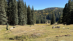 |
|
2 |
-
| |  |
|
1 |
-
| 1 label | 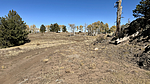 |
|
|
-
-
-
-
-
| 1 label | 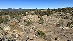 |
|
|
-
| 2 labels | 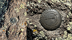 |
|
|
-
| 1 label | 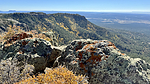 |
|
|
-
| 1 label | 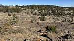 |
|
|
-
| |  |
|
2 |
-
-
| 1 label | 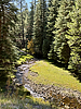 |
|
|
-
| 1 label | 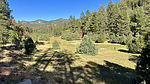 |
|
|
|
| | Matthews Peak - Cliff BM, AZ | | | |
|
|
Matthews Peak - Cliff BM, AZ
| | |
|
| Hiking | 1.14 Miles |
161 AEG |
| | Hiking | 1.14 Miles | 38 Mns | | 2.14 mph |
| 161 ft AEG | 6 Mns Break | | | |
|
|
| |
| Linked |
|
none
[ show ]
| no linked trail guides |
| Partners |
|
none
[ show ]
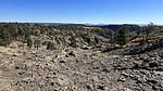
| no partners | | I decided to have a look at the Cliff BM. The road to get there is a bit rough, and the Matt high point is in somebody's front yard, so I skipped that point and headed out to the find the survey disks. And it is for sure a cliff! About 400 feet absolutely vertical. This results in some nice views!
I only found one reference mark, and it had been re-stamped to point to a tiny coin-sized benchmark, which I presume is a replacement for the original disk that no longer exists. Huh.
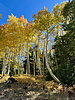
The geology out here is 90 180 270 360 and all other angles from other spots I'd visited. It resembled a barren lava field of exposed, unvegitated rock. I'll have to read up on the the how and why of the unique landscape on this escarpment. A cool area. Lots of aspen, and a few more deer encountered. |
| _____________________
| I'm not sure what my spirit animal is, but I'm confident it has rabies. |
| | |
|
|
|
|
|
| |
 Route Editor


